
Size of the crater

Width of the World Trade Center site: 0.23 miles

The above crater which is 0.09 miles could fit in the World Trade Center site twice.

Sedan crater, approx the same area (0.25 miles diameter) as the World Trade Center. But that was 104 kt and is the biggest nuke crater in Nevada.

Image: http://nuclearweaponarchive.org/Usa/Tests/SubsidenceCrater347c20.jpg http://nuclearweaponarchive.org/Usa/Tests/Nts.html (The Nuclear Weapon Archive: A Guide to Nuclear Weapons by Carey Sublette) Caption: Typical Nevada Test Site subsidence crater
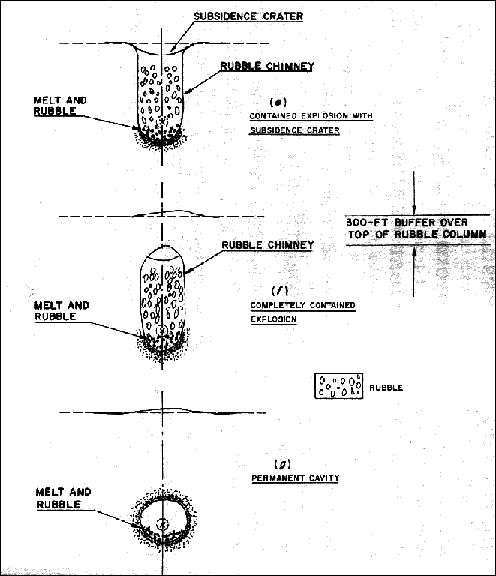
Underground testing often leaves visible evidence on the surface in the form of subsidence craters (more accurately called ‘sinks’). These are depressions on the surface that come about when the roof of the blast cavity collapses in to the void left by the explosion. This creates a new roof, which can also shear off into the new, larger, but partially rubble-filled cavity. A chain reaction of successive roof collapses forms a “chimney” that works its way to the surface.
http://nuclearweaponarchive.org/Usa/Tests/Nts.html
Formation of a Subsidence Crater
This photo sequence (taken by a circling helicopter) shows the after effects of an underground test. In the first frame (one minute after the test) dust suspended in the air by the shock wave can be seen (with difficulty). The 100 foot shot observation tower then moves back to a safe distance from the center of the shot. At 23 minutes after the test, the surface of the ground caves in to form a crater.

http://nuclearweaponarchive.org/Usa/Tests/Ntscrater2s.jpg
Caption: Subsidence Crater Formation at Nevada Test Site
Development of chimney

http://nuclearweaponarchive.org/Library/Effects/SubsidenceDiag669.gif URL: http://nuclearweaponarchive.org/Usa/Tests/Nts.html Caption: Crater cross-section
in alluvium.
[Teller et al 1968; p. 140]
http://nuclearweaponarchive.org/Library/Effects/CraterDiag1B661.gif URL: http://nuclearweaponarchive.org/Usa/Tests/Nts.html Caption: Formation of a Subsidence Crater
[Teller et al 1968; p. 128]
http://nuclearweaponarchive.org/Usa/Tests/Nts.html

Image: Unknown origin

http://rst.gsfc.nasa.gov/Sect18/Shoemaker.jpg URL: http://rst.gsfc.nasa.gov/Sect18/Sect18_5.html Caption: Shoemaker also was the first to study nuclear explosion craters at the Nevada Test Site (NTS)
Subsidence crater

http://upload.wikimedia.org/wikipedia/en/a/ae/Subsidence_crater.jpg URL: http://en.wikipedia.org/wiki/Subsidence_crater
Caption: Post-shot subsidence crater and Huron King test chamber, which was less than 20 kilotons (1980)
A subsidence crater is a hole or depression left on the surface of an area which has had an underground (usually nuclear) explosion. Many such craters are present at the Nevada Test Site, which is no longer in use for nuclear testing.
Subsidence craters are created as the roof of the cavity caused by the explosion collapses. This causes the surface to depress into a sink (which subsidence craters are sometimes called). It is possible for further collapse to occur from the sink into the explosion chamber. When this collapse reaches the surface, and the chamber is exposed atmospherically to the surface, it is referred to as a chimney.
It is at the point that a chimney is formed through which radioactive fallout may reach the surface. At the Nevada Test Site, depths of 100 to 500 meters (330 to 1,600 ft) were used for tests.
http://en.wikipedia.org/wiki/Subsidence_crater
Sedan test
Storax Sedan was a shallow underground nuclear test conducted in Area 10 of Yucca Flat at the Nevada National Security Site on 6 July 1962 as part of Operation Plowshare, a program to investigate the use of nuclear weapons for mining, cratering, and other civilian purposes. [..]
Sedan was a thermonuclear device with a fission yield less than 30% and a fusion yield about 70%. The timing of the test put it within the Operation Storax fiscal year, but Sedan was functionally part of Operation Plowshare, and the test protocol was sponsored and conducted by Lawrence Livermore National Laboratory with minimal involvement by the United States Department of Defense. The explosive device was lowered into a shaft drilled into the desert alluvium 194 m (636 ft) deep. The fusion-fission blast had a yield equivalent to 104 kilotons of TNT (435 terajoules) and lifted a dome of earth 290 feet (90 m) above the desert floor before it vented at three seconds after detonation, exploding upward and outward displacing more than 11,000,000 t (11,000,000 LT; 12,000,000 ST) of soil. The resulting crater is 100 m (330 ft) deep with a diameter of about 390 m (1,280 ft). A circular area of the desert floor five miles across was obscured by fast-expanding dust clouds moving out horizontally from the base surge, akin to pyroclastic surge. The blast caused seismic waves equivalent to an earthquake of 4.75 on the Richter scale. [..]
The Plowshare project developed the Sedan test in order to determine the feasibility of using nuclear detonations to quickly and economically excavate large amounts of dirt and rock. Proposed applications included the creation of harbors, canals, open pit mines, railroad and highway cuts through mountainous terrain and the construction of dams. Assessment of the full effects of the Sedan shot showed that the radioactive fallout from such uses would be extensive. Public concerns about the health effects and a lack of political support eventually led to abandonment of the concept.

http://upload.wikimedia.org/wikipedia/commons/thumb/7/7d/Storax_Sedan_nuke.jpg/300px-Storax_Sedan_nuke.jpg URL: http://en.wikipedia.org/wiki/Sedan_%28nuclear_test%29 Caption: Storax Sedan explosion

http://upload.wikimedia.org/wikipedia/commons/thumb/b/b6/Sedan_Plowshare_Crater.jpg/300px-Sedan_Plowshare_Crater.jpg URL: http://en.wikipedia.org/wiki/Sedan_%28nuclear_test%29
Sedan test
VIDEO: Sedan Nuclear Test – Original Military Film
“Storax Sedan was a shallow underground nuclear test conducted in Area 10 of Yucca Flat at the Nevada Test Site on 6 July 1962 as part of Operation Plowshare, a program to investigate the use of nuclear weapons for mining, cratering, and other civilian purposes.[1] The radioactive fallout from the test contaminated more US residents than any other nuclear test, and the Sedan Crater is the largest man-made crater in the United States, and is listed on the National Register of Historic Places” Wikipedia
Underground nuclear testing
Underground nuclear testing refers to test detonations of nuclear weapons that are performed underground. When the device being tested is buried at sufficient depth, the explosion may be contained, with no release of radioactive materials to the atmosphere.
The extreme heat and pressure of an underground nuclear explosion causes changes in the surrounding rock. The rock closest to the location of the test is vaporised, forming a cavity. Further away, there are zones of crushed, cracked, and irreversibly strained rock. Following the explosion, the rock above the cavity may collapse, forming a rubble chimney. If this chimney reaches the surface, a bowl-shaped subsidence crater may form. [..]
The first underground nuclear test was conducted on 29 November 1951. This was the 1.2 kiloton Buster-Jangle Uncle, detonated 5.2 m (17 ft) beneath ground level. The test was designed as a scaled-down investigation of the effects of a 23 kiloton ground penetrating gun-type device that was then being considered for use as a cratering and bunker-buster weapon. The explosion resulted in a cloud that rose to 11,500 ft, and deposited fallout to the north and north-northeast. The resulting crater was 260 feet wide and 53 feet deep.
The next underground test was Teapot Ess, on 23 March 1955. The 1 kiloton explosion was an operational test of an atomic demolition munition (ADM). It was detonated 67 feet underground, in a shaft lined with corrugated steel, which was then back-filled with sandbags and dirt. Because the ADM was buried underground, the explosion blew tons of earth upwards, creating a crater 300 feet wide and 128 feet deep. The resulting mushroom cloud rose to a height of 12,000 feet and subsequent radioactive fallout drifted in an easterly direction, travelling as far as 225 km from ground zero. [..]
The effects of an underground nuclear test may vary according to factors including the depth and yield of the explosion, as well as the nature of the surrounding rock. If the test is conducted at sufficient depth, the test is said to be contained, with no venting of gases or other contaminants to the environment. [..] One figure used in determining how deeply the device should be buried is the scaled depth of burial, or -burst. This figure is calculated as the burial depth in metres divided by the cube root of the yield in kilotons. It is estimated that, in order to ensure containment, this figure should be greater than 100.
The energy of the nuclear explosion is released in one microsecond. In the following few microseconds, the test hardware and surrounding rock are vaporised, with temperatures of several million degrees and pressures of several million atmospheres. Within milliseconds, a bubble of high-pressure gas and steam is formed. The heat and expanding shock wave cause the surrounding rock to vaporise, or being melted further away, creating a melt cavity. The shock-induced motion and high internal pressure cause this cavity to expand outwards, which continues over several tenths of a second until the pressure has fallen sufficiently, to the level equal to the level roughly comparable with the weight of the rock above, and can no longer grow. Although not observed in every explosion, four distinct zones (including the melt cavity) have been described in the surrounding rock. The crushed zone, about two times the radius of the cavity, consists of rock that has lost all of its former integrity. The cracked zone, about three times the cavity radius, consists of rock with radial and concentric fissures. Finally, the zone of irreversible strain consists of rock deformed by the pressure. The following layer undergoes only an elastic deformation; the strain and subsequent release then forms a seismic wave. [..]
![]()
http://upload.wikimedia.org/wikipedia/en/4/44/UncleNuclearTest1951.jpg URL: http://en.wikipedia.org/wiki/Underground_nuclear_testing Caption: The 1951 Uncle test – the first underground nuclear explosion
http://en.wikipedia.org/wiki/Underground_nuclear_testing
Video – Underground nuclear test
VIDEO: Underground Nuclear Test
Caption: “Subsidence Crater Formation
Historic underground nuclear test causes the surface to subside which forms a crater – seven such craters are used as disposal cells at the Area 3 Radioactive Waste Management Site. Provided by the US Department of Energy under Public Domain rules.”
Video of underground test – Teapot Ess
VIDEO: Underground nuclear testing Teapot Ess
Caption: “This LASL test was the sixth to use the Ranger Able U-235 core, this time in a Mk-6 HE assembly. Ess (“Effects Sub-Surface”) was a test of atomic demolition munition (ADM) cratering. The 8000 lb bomb was placed in a shaft lined with corrugated steel,10 feet wide and 70 feet deep (so that the bomb center was at -67 feet), which was back-filled with sandbags and dirt prior to firing. The crater was 300 feet wide and 128 feet deep.”
Possibilities for Peaceful nuclear explosives
The first formal programme for peaceful applications was announced by the USA in 1957, under the title ” Plowshare “. [..]
In 1961 and subsequently, the USA again performed underground nuclear experiments, including the first nuclear Plowshare test, project GNOME. Since then, experience has been accumulated and codified, and it is possible to consider international applications of a commercial nature.
What happens underground
In order to understand better the possible applications which have been proposed, it is useful to review and discuss what happens in an underground nuclear explosion.
In the first phase of firing (which lasts only for millionths of a second) almost all the energy of the nuclear explosion is released. A fireball, in which internal temperatures of millions of degrees and internal pressures of millions of atmospheres exist, is formed. The surrounding rock is vapourised by absorption of energy from radiant heat and other radiations, with a boundary of molten rock. Thus, a cavity several metres across may be formed.
Within a few thousandths of a second, the pressure wave within the cavity strikes the cavity wall. The cavity is further expanded by plastic deformation of the surrounding rock, and the fluid layer increases in thickness through melting following some absorption of the mechanical energy. Most of the pressure energy is converted into a shock wave which travels outward from the explosion. Until its energy has been dissipated, this Shockwave interacts with the surrounding rock by crushing and fracturing it. This behaviour, as is the case with the other shock phenomena described below, is not qualitatively different from the effects of chemical high explosive shots; the differences are in scale – the much larger energy in the nuclear shock and the smaller relative size of the central cavity.
Within a period of seconds, the molten rock liner of the cavity starts to flow and aggregates at the bottom. This molten zone contains most of the radioactivity of the nuclear explosion. Ultimately it will freeze, and it is finally found as a bowl-shaped mass, considerably cracked as a result of thermal stresses and of mechanical blows from other rock falling on to it.
In a contained explosion, the fractured rock zone above the cavity is not solid enough to bridge over the hole. Some of the broken rock falls in from above, filling the cavity with looser rock. As this happens, more rock continues to fall from above, until the point is reached at which this relatively loosely packed region begins again to support the rock above it, and the less badly shattered rock acts as a bridge. The result is a cylinder filled to low density with broken rock, called a “chimney”. If the explosion is deep underground, no surface effect can be seen. It is possible, however, for chimney formation to result in some slumping of the earth at ground level; if the explosion were too close to the surface, the chimney could extend to the surface, and cracks in the ground would be found.
For cratering activities, the explosive is detonated at a depth such that the shock wave will reach the surface and be partially reflected and refracted at the ground-air interface. The returning wave reaches the cavity while it is still growing, and causes it to expand preferentially upward and outward.
As a result, a large dome of earth and rock rises above ground level. Ultimately the dome is breached, through a combination of effects: decreased cavity pressure from its expansion, release of cavity gas through fissures in the dome, and gravity. Then the dome falls back; however, by this time a large mass of material has been pushed outward. The result is a crater, with a rim of crushed, loose rock, and a floor of broken rock lying above the location of the detonation. The molten and resolidified rock zone still exists, but is buried under the crater floor.
As indicated, the largest part of the radioactivity in the nuclear explosion is retained in the molten zone. Most of the rest is retained on the surfaces of the crushed and fractured rocks, which are good natural sieves for particulate matter and absorbers for vapour. In a cratering explosion, however, some radioactivity will escape to the atmosphere. The amount of fission products is estimated as a very small fraction of the potential quantity: in a 25 kiloton explosion, which is largely thermonuclear, fission product release is limited to the products of a 20 ton fission explosion – about 8 grammes of product. Neutron activation is minimised by surrounding the explosive with a non-activating, neutron absorbing shield. Some tritium from the thermonuclear explosion is released.
Comparisons with TNT
As has been mentioned, the nuclear explosion differs in equivalent size from chemical high explosives by several orders of magnitude. A 25 kiloton nuclear explosive (TNT equivalent – 2 5 000 tons) may be emplaced in a cylindrical bore hole less than a metre in diameter; even a 1 megaton explosive charge (TNT equivalent – 1 000 000 tons) would not take up more space than that. On the other hand, 25 000 tons of TNT would require a spherical cavity, 30 metres in diameter. Even if that much TNT could be assembled in one place, its emplacement costs would be enormous.
(In this article Bernard I. Spinrad, Director of the Division of Nuclear Power and Reactors, summarizes information at present available.)
100 kiloton shallow underground burst
2 SECONDS

Figure 2.93a. Chronological development of a 100 kiloton shallow underground burst; 2 seconds after detonation.
When a nuclear explosion occurs at a shallow depth underground, the fireball breaks through the surface of the earth within a fraction of a second of the instant of detonation. The intensely hot gases at high pressure are released and they carry up with them into the air large quantities of soil, rock, and debris in the form of a hollow column. For a burst at a shallow depth, the column tends to assume the shape of an inverted cone which fans out as it rises, to produce a radial throw-out. A highly radioactive cloud, which contains large quantities of earth, is formed above the throw-out as the hot vapors cool and condense. Because of the mass displacement of material from the earth’s surface, a crater is formed. For a 100-kiloton weapon exploding 50 feet beneath the surface of dry soil, the crater would be about 120 feet deep and 720 feet across. The weight of the material removed would be over a million tons.
In addition to the shock (or pressure) wave in the ground, somewhat related to an earthquake wave, the explosion is accompanied by a blast wave in the air. At 2 seconds after the explosion, the blast wave front in air is about 3/4 mile from surface zero.
9 SECONDS

Figure 2.93b. Chronological development of a 100 kiloton shallow underground burst; 9 seconds after detonation.
The radioactive cloud continues to rise, giving off intense nuclear radiations which are still a hazard on the ground at 9 seconds after the detonation. At this time, the larger pieces of rock and debris in the throw-out begin to descend to earth.
45 SECONDS

Figure 2.93c. Chronological development of a 100 kiloton shallow underground burst; 45 seconds after detonation.
As the material from the column descends, the finer soil particles attain a high velocity and upon reaching the ground they spread out rapidly to form a base surge similar to that in an underwater explosion. The extent of the base surge, which is likely to be radioactive, depends upon many factors, including the energy yield of the explosion, the depth of burst, and the nature of the soil. It is believed that a dry sandy terrain would be particularly conducive to base surge formation.
4.5 MINUTES

Figure 2.93d. Chronological development of a 100 kiloton shallow underground burst; 4.5 minutes after detonation.
The base surge increases in height and area and soon begins to merge with the radioactive cloud of weapon residues, etc., part of which descends and spreads out under the influence of the prevailing winds. In due course, the radioactive clouds disperse, but the contaminated particles descend to earth to produce a hazardous fallout over a large area, especially in the downwind direction, during the course of a few hours.
From The Effects of Nuclear Weapons, Samuel Glasstone, ed., USAEC, Washington, DC, April 1962; Revised Edition reprinted February 1964.
Digital version by Gregory Walker (trinatomic at earthlink dot net).
Copyright © 1995-2003 Gregory Walker (trinatomic at earthlink dot net), Creator of Trinity Atomic Web Site.
http://www.cddc.vt.edu/host/atomic/nukeffct/undrwtr.html
Radioactive glass
Trinitite – from Wikipedia
Trinitite, also known as Atomsite or Alamogordo Glass, is the name given to the glassy residue left on the desert floor after the plutonium-based Trinity nuclear bomb test on July 16, 1945, near Alamogordo, New Mexico. The glass is primarily composed of arkosic sand composed of quartz grains and feldspar (both microcline and smaller amount of plagioclase with small amount of calcite, hornblende and augite in a matrix of sandy clay)[2] that was melted by the atomic blast. It is usually a light green, although color can vary. It is mildly radioactive, but is safe to handle [..]
Formation
In 2005 it was theorized by Los Alamos National Laboratory scientist Robert Hermes and independent investigator William Strickfaden that much of the mineral was formed by sand which was drawn up inside the fireball itself and then rained down in a liquid form.
A number of different types of Trinitite have been identified. Green is the most common form. Black contains iron from the tower structure. Red contains copper from the device itself or from the communications cables that led away from the site. Both black and red specimens are extremely rare. Rounded pearls are also found which come from melted silica that returned to solid form before hitting the ground.
The glass has been described as “a layer 1 to 2 centimeters thick, with the upper surface marked by a very thin sprinkling of dust which fell upon it while it was still molten. At the bottom is a thicker film of partially fused material, which grades into the soil from which it was derived. The color of the glass is a pale bottle green, and the material is extremely vesicular with the size of the bubbles ranging to nearly the full thickness of the specimen.”
The name trinitite is occasionally broadly applied to all glassy residues of nuclear bomb testing, not just the Trinity test. An analog of Trinitite found in Semipalatinsk Test Site in Kazachstan at ground zeroes of Soviet atmosperic nuclear tests is called Kharitonchik. Black vitreous fragments of fused sand that had been solidified by the heat of the explosion were described from French test site in Algeria (Reggane site).
http://en.wikipedia.org/wiki/Trinitite
Trinitite
Trinitite is the name given to the soil that was fused into a glass-like consistency by the heat from the Trinity Test, the world’s first nuclear explosion that took place July 16, 1945 at Alamogordo New Mexico . [..] Trinitite typically has a grayish-green color. Individual pieces are usually 1 cm thick and several grams in weight. As a rule, one surface is smooth [..] while the other side has a highly irregular texture. [..]
Trinitite is measurably radioactive, but not dangerously so. [..]
As the radionuclides created by the explosion decay away, Trinitite becomes less and less radioactive. Which radionuclides are identified today depends on how much trouble and time one is willing to devote to the analysis. A simple analysis by gamma spectroscopy reveals the presence of Cs-137, Am-241, Ba-133, Co-60, Eu-152, Eu-154 and Eu-155 (the Co-60 and Eu-155 were present at very low levels but they were still detectable as of March 2005). A number of harder to detect pure alpha and beta radionuclides will also be present, e.g., Sr-90, Pu-239 and Pu-241. Needless to say, naturally occurring nuclides such as K-40 and the various members of the uranium and thorium decay series are also present.
http://www.orau.org/ptp/collection/hiroshimatrinity/trinitite.htm
Nuclear debris could reveal clues of bomb’s origin
By Katia Moskvitch | BBCNews 2010 11 16
Forensic analysis of the debris left after a nuclear explosion could yield crucial evidence about the composition and the origin of the bomb, say scientists.
A US team examined Trinitite [right], the glassy ground debris from the first-ever nuclear test that the US Army conducted in 1945 in New Mexico.
They used advanced analytical techniques to reveal details about the materials used to construct the bomb.
The study appears in the journal PNAS.
http://www.redicecreations.com/article.php?id=13207
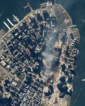
http://www.planetizen.com/files/oped/20010917fullmanhattan0915.jpg
http://www.planetizen.com/node/27 Caption: Lower Manhattan on September 15, 2001. Image provided by spaceimaging.com.
http://drjudywood.com/articles/DEW/StarWarsBeam4.html

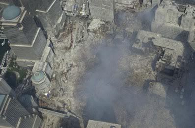
http://www.911research.com/wtc/evidence/photos/groundzero.html Caption: Satellite photo of Ground Zero
Craters

http://images2.webpark.ru/uploads52/080722/nukleus_06.jpg URL: http://www.cddc.vt.edu/host/atomic/nukeffct/undrgnd.html Caption: craters
Formation of craters
![]()
TIFF from: http://www.fas.org/sgp/othergov/doe/lanl/osti/671858.pdf URL: http://www.fas.org/sgp/othergov/doe/lanl/osti/671858.html Caption: DOE Title Surface effects of underground nuclear explosions
Creator/Author Allen, B.M.; Drellack, S.L. Jr.; Townsend, M.J.
Publication Date 1997 Jun 01

TIFF from: http://www.fas.org/sgp/othergov/doe/lanl/osti/671858.pdf URL: http://www.fas.org/sgp/othergov/doe/lanl/osti/671858.html Caption: DOE Title Surface effects of underground nuclear explosions
Creator/Author Allen, B.M.; Drellack, S.L. Jr.; Townsend, M.J.
Publication Date 1997 Jun 01
Underground nuclear explosion

http://bp2.blogger.com/_osrVjnPbdEM/SIXgyQ8exmI/AAAAAAAACz8/iT-Fsd7vVjw/s400/Underground_Nuclear_Explosion_3.jpg URL: http://www.popgive.com/2008/07/underground-nuclear-explosion.html

Image: http://upload.wikimedia.org/wikipedia/commons/b/b6/Sedan_Plowshare_Crater.jpg URL: http://en.wikipedia.org/wiki/Operation_Plowshare Caption: The 1962 “Sedan” plowshares shot displaced 12 million tons of earth and created a crater 320 feet (100 m) deep and 1,280 feet (390 m) wide.

http://www.fas.org/irp/imint/doe_nts_schooner.jpg URL: http://www.fas.org/nuke/guide/usa/facility/nts.htm Caption: Nevada Test Site (NTS)
Schooner Crater
Pot hole/crater of Ground Zero

http://graphics8.nytimes.com/images/2008/09/22/nyregion/22rocks_650.jpg URL: http://www.nytimes.com/2008/09/22/nyregion/22rocks.html?_r=2&ref=nyregion&oref=slogin Caption: David W. Dunlap/The New York Times. Excavation at the World Trade Center site has uncovered, among other geologic features, a 40-foot glacial pothole.

http://graphics8.nytimes.com/images/2008/09/22/nyregion/22rocks2_650.jpg URL: http://www.nytimes.com/2008/09/22/nyregion/22rocks.html?_r=2&ref=nyregion&oref=slogin Caption: David W. Dunlap/The New York Times A worker is framed by bedrock that was scoured by a retreating glacier 20,000 years ago. At Ground Zero, Scenes From the Ice Age By DAVID W. DUNLAP Published: September 21, 2008
At Ground Zero, Scenes From the Ice Age
By DAVID W. DUNLAP. Published: September 21, 2008
Those who say the World Trade Center site is changing at a glacial pace have no idea how right they are.
A fantastic landscape in Lower Manhattan — plummeting holes, steep cliffsides and soft billows of steel-gray bedrock, punctuated by thousands of beach-smooth cobblestones in a muted rainbow of reds and purples and greens — has basked in sunlight this summer for the first time in millennia.
This monumental carving was the work of glaciers, which made their last retreat from these parts about 20,000 years ago, leaving profound gouges in the earth and rocks from the Palisades, the Ramapo Mountains and an area of northern New Jersey known as the Newark Basin.
Plumbing these glacial features and souvenirs has been critical in preparing the foundation for Tower 4 of the new World Trade Center, being built by Silverstein Properties. The concrete footings from which its columns rise must rest on firm bedrock. Engineers need a clear understanding of the rock’s contours.
“You want to make sure you’re not perching something on a ledge,” said Andrew Pontecorvo, a supervising structural engineer at Mueser Rutledge Consulting Engineers, which is working on the trade center project.
Engineers knew in advance that there were “discontinuities” in the bedrock at the southeast corner of the trade center site, where Tower 4 is situated. Some of these were revealed in the 1960s during the construction of the original slurry wall. (George J. Tamaro, who supervised that job for the Port Authority of New York and New Jersey, is a retired partner of Mueser Rutledge.)
And when parts of the slurry wall were rebuilt after 9/11, engineers found areas where the rock anchors that stabilize the wall would not hold, meaning there were voids in the bedrock.
Borings through the ground also showed large discrepancies in the elevation of the rock underneath. “It was extreme from the variation you would interpret to what we actually encountered,” Mr. Pontecorvo said.
Obviously, the bedrock topography could not be mapped with enough precision until all the soil was removed and the surface was fully exposed. But besides being an engineering necessity, the unearthing of geological features, especially a 40-foot depression known as a pothole, has offered scientists a rare window into the deep past.
“There are areas in local parks that have small vertical potholes exposed,” said Cheryl J. Moss, the senior geologist at Mueser Rutledge, “but I’m not aware of anything in the city with a whole, self-contained depression on this scale.”
Ms. Moss and Mr. Pontecorvo are scheduled to give an illustrated lecture on the site at 7 p.m. Wednesday at the Tribute W.T.C. Visitor Center, 120 Liberty Street, opposite the pothole.
“It’s been called the Grand Canyon of Lower Manhattan,” Mr. Pontecorvo said.
Charles Merguerian, chairman of the geology department at Hofstra University and a consultant to Mueser Rutledge on the trade center project, put it even more simply: “Beautiful!”
“It is very unusual to see such features near sea level,” he added.
Shown photographs of the rocks, Sidney Horenstein, a geologist and environmental educator emeritus at the American Museum of Natural History, said, “You don’t find such an array of rock types in the few places in the city that the glacial deposits are exposed.”
Across much of the trade center site, bedrock level is roughly 70 feet below street level. In the southeast corner, however, the pothole adds another 40 feet to the depth, meaning that its bottom is about 110 feet below street level.
Yet when the pothole filled with rainwater this summer, it looked like nothing so much as a little mountain pond. Crevices around the edge were filled with pockets of densely packed cobblestones, possibly some of the very stones that the glaciers used to do the carving.
“As the ice passed over New Jersey,” Ms. Moss explained, “it picked up local rocks such as red shale and sandstone and gray basalt from the Palisades. As ice melted from the advancing glacier, raging streams of water flowed in front of it. The strong currents picked up the sand, gravel and boulders and carried them downstream across the World Trade Center site.
“As these rocks bounced across the bedrock, essentially sandblasting the surface, the softer layers started to erode out and the harder rock left behind became polished. In places, the water swirled in whirlpools of varying sizes, carving out deep potholes and larger basins.”
Along the east side of the pothole, the rock layers run vertically — not horizontally. The result, where the surface has been carved away in a concave form, is an abstract canvas of swirling, concentric rings; not unlike a gouge in a wall that reveals many layers of old paint.
This speaks of a period far more ancient than the glaciers, about 500 million years ago, when the edges of the colliding North American and African continental plates got shuffled together.
“That’s when all this got pushed into a vertical orientation,” Dr. Merguerian said. He estimated that the rock around the pothole had once been 20 miles below the surface, based on the presence of a high-pressure mineral called kyanite.
Ultimately, geology at the trade center site is in the service of construction, meaning that the pothole and other features are either being covered, filled in or blasted away. “It’s nice to look at,” said Robert B. Reina, a supervising structural engineer at Mueser Rutledge, “but it’s all got to go.”
Construction workers have developed an appreciation of this otherworldly site, even as they have labored to obliterate it. For instance, Joe Racanelli, a foreman, has been collecting those smooth and colorful cobblestones from New Jersey and lugging them home to the Bronx.
“I can’t help it,” he admitted.
And a mechanic who introduced himself simply as Al made it plain that this was one New York pothole he would miss.
“I think they should keep it,” he said. “Turn it into an aquarium. Fill it with fish. Do something special — not just another building.”
Gnome cavity
Operation Nougat (from Nuclear Weapons Archive)
[..] This series was conducted at the Nevada Test Site, which permitted rapid initiation of tests, but restricted them to low yields (and mostly underground test shots) due to fallout concerns. Although this was still the “era of atmospheric testing”, Nougat was actually the first underground test series. […]
The assignment of tests to individual “operations” between this time and the end of atmospheric testing is confused and complicated by several overlapping operations – Nougat, Dominic (or Dominic I), Sunbeam (or Dominic II), Fishbowl, Storax, and Roller Coaster. [..]
Nougat generally resembles Hardtack II in the nature of testing that was conducted. Low yield tactical devices were extensively tested. Thermonuclear primaries and radiation imploson mockups were tested. Much attention was paid to simultaneously achieving desired performance and one-point safety in “sealed pit” fission devices, some designs requiring numerous shots.
Since all the tests were fired underground, and only a few of them produced true blast craters (i.e. not subsidence craters caused by blast cavity collapse), there are few pictures available of these tests.
The one test for which any relevant images are available is much publicized Gnome shot.

http://upload.wikimedia.org/wikipedia/commons/c/ce/Nougat_Gnome.jpg URL: http://en.wikipedia.org/wiki/Operation_Nougat Caption: Nougat Gnome Crater. See the man standing under the arrow. This gives some idea of the size of the cavity.
Test: Gnome
Time: 12:10 10 December 1961 (GMT)Location: Carlsbad, NM
Test Height and Type: Shaft Shot, -1184 ft
Yield: 3.1 kt
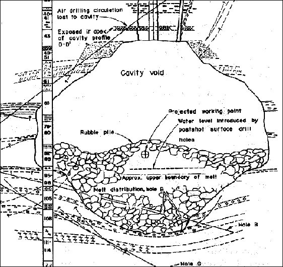
TIFF from: http://nuclearweaponarchive.org/Usa/Tests/GnomeDiag1024.gif URL: http://nuclearweaponarchive.org/Usa/Tests/Nougat.html Caption: Gnome cavity. The one test for which any relevant images are available is much publicized Gnome shot.
http://nuclearweaponarchive.org/Usa/Tests/Nougat.html
Comparison of crater cavities

IMG1: http://nuclearweaponarchive.org/Usa/Tests/Gnome347c20.jpg URL: http://nuclearweaponarchive.org/Usa/Tests/Nougat.html Caption: Gnome cavity; see the man standing under the arrow in the image; this gives some idea of the size of the cavity. IMG2: http://graphics8.nytimes.com/images/2008/09/22/nyregion/22rocks_190.jpg URL: http://www.nytimes.com/2008/09/22/nyregion/22rocks.html?_r=3&ref=nyregion&oref=slogin Caption: David W. Dunlap/The New York Times
Excavation at the World Trade Center site has uncovered, among other geologic features, a 40-foot glacial pothole.

Img 1: http://nuclearweaponarchive.org/Usa/Tests/GnomeDiag439.gif URL: http://nuclearweaponarchive.org/Usa/Tests/Nougat.html Caption: Gnome diagram Img 2: http://graphics8.nytimes.com/images/2008/09/22/nyregion/22rocks_650.jpg URL: http://www.nytimes.com/2008/09/22/nyregion/22rocks.html?_r=3&ref=nyregion&oref=slogin Caption: David W. Dunlap/The New York Times. Excavation at the World Trade Center site has uncovered, among other geologic features, a 40-foot glacial pothole.

Image 1: http://www.fas.org/irp/imint/doe_nts_schooner.jpg URL: http://www.fas.org/nuke/guide/usa/facility/nts.htm Caption: Nevada Test Site (NTS)
Schooner Crater Img 2: http://graphics8.nytimes.com/images/2008/09/22/nyregion/22rocks_650.jpg URL: http://www.nytimes.com/2008/09/22/nyregion/22rocks.html?_r=3&ref=nyregion&oref=slogin Caption: David W. Dunlap/The New York Times Excavation at the World Trade Center site has uncovered, among other geologic features, a 40-foot glacial pothole .. A fantastic landscape in Lower Manhattan — plummeting holes, steep cliffsides and soft billows of steel-gray bedrock, punctuated by thousands of beach-smooth cobblestones in a muted rainbow of reds and purples and greens — has basked in sunlight this summer for the first time in millennia.
Pebbles and nuclear explosions
Green, red and black pebbles at the Trinity Test Site
Twice a year, on the first Saturday of April and October, the Trinity Test Site, where the first nuclear bomb was exploded, is open to the public. [..]
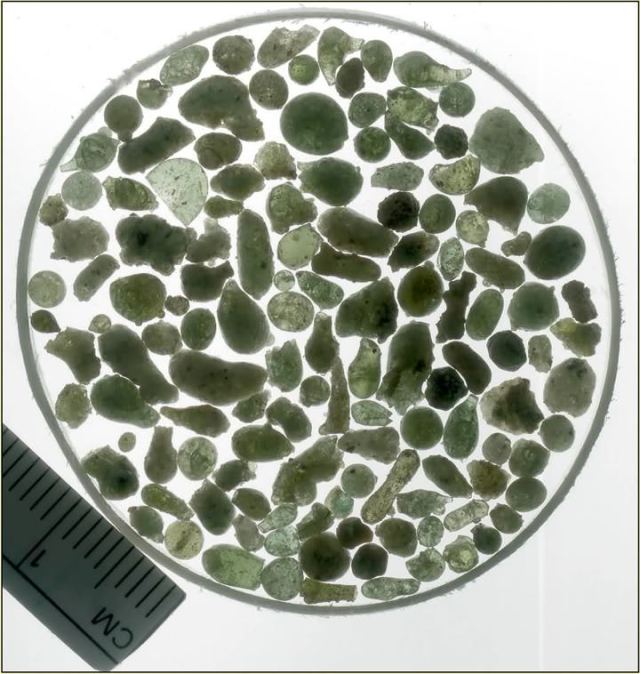
On the sandy floor of the test site there are pieces of trinitite, blue-green pebbles of glass that were created when the bomb exploded. Some of the trinitite is also red or black, and contains copper or iron from the vaporized bomb and tower.
(“The Geek Atlas: 128 Places where Science and Technology Come Alive” by John Graham-Cumming p.418)
Emerald-colored glassy rocks at Trinity
From Discover Magazine: The Pretty, Desolate Spot Where the Nuclear Age Began
by Leeaundra Keany March 3, 2010
At the entrance to the Trinity Site, you are greeted by vendors selling T-shirts, commemorative patches, hot dogs, hamburgers, and drinks. [..]
In fact, a popular activity at the Trinity open house is searching for Trinitite, emerald-colored glassy rocks formed from sand caught up in the firestorm of the nuclear blast—in essence, shards of fallout. Immediately after the test, the site was covered with the stuff, but bulldozers—aided by time and constant pilfering—have made it scarce. [..]
I eventually find several chunks of the real stuff that beg to be taken home and made into earrings. Unfortunately, because the site is a national historic landmark, it is a federal crime to remove Trinitite. Blevins sees me eye the pebbles covetously and warns, “We’re not making any more of it.” Trinitite is also slightly radioactive, so wearing it close to my brain would probably be unwise.
Glass produced by underground nuclear explosions
L. Schwartz1, A. Piwinskii1, F. Ryerson, H. Tewes and W. Beiriger – Glass in Planetary and Geological Phenomena, New York State College of Ceramics, Alfred, N.Y. 14802, USA
Abstract
Detonation of an underground nuclear explosive deposits a large amount of energy in what can be considered to be a point source in space and time. The strong shock wave produced propagates spherically outward, initially vaporizing the explosive and nearby rock and subsequently melting, then heating the surrounding rock as the energy density decreases. The vaporized material expands adiabatically forming a cavity. As the energy in the vaporized material is dissipated during the cavity formation process, the explosive and rock debris condense and mix with the melted rock. The melt flows to the bottom of the cavity where it is cooled and quenched by fractured rock fragments falling from above as the cavity collapses. Measurements on a large number of underground nuclear explosions indicate that approximately 740 tons of rock and/or soil are melted for every kiloton (1012 cal) of explosive energy, or approximately 25% of the explosive energy goes to melting rock. The resulting glass composition reflects the composition of the unaltered rock with debris from the explosive added. A wide range of physical appearances has been observed, ranging from white pumice to dense, dark lava. In general, bulk composition and color vary with the amount of explosive iron incorporated into the glass. By inference, all the refractory explosion products are mixed with the solidified melt, although the degree of mixing inferred is highly variable. Recent electron microprobe studies of glasses produced by the low yield Rainier event in welded tuff have produced the following results: (1) glasses are dehydrated relative to the host media, (2) glasses are extremely heterogeneous with respect to major element chemistry on a 20 μm scale, (3) a ubiquitous feature is the presence of dark “marble-cake” regions in the glass; these are locally enriched in iron and may be related to the nuclear device debris, (4) optically amorphous regions with chemistries of the crystalline phases are found in the glasses and provide evidence of shock melting, (5) only limited major element redistribution and homogenization occur within the cavity. The short duration of the thermal pulse and the high viscosity of the melts produced by the Rainier event precluded re-homogenization by diffusion or convection, respectively.
Journal of Non-Crystalline Solids. Volume 67, Issues 1-3, September 1984, Pages 559-591
THE PRODUCTION AND DISSOLUTION OF NUCLEAR EXPLOSIVE MELT GLASSES AT UNDERGROUND TEST SITES IN THE PACIFIC REGION* D.K. SMITH**, W.L. BOURCIER*** Lawrence Livermore National Laboratory P.O. Box 808, M/S L-231 Livermore, California 94550 United States of America
Abstract
From 1975 to 1996 the French detonated 140 underground nuclear explosions beneath the atolls of Mururoa and Fangataufa in the South Pacific; from 1965 to 1971 the United States detonated three high yield nuclear tests beneath Amchitka Island in the Aleutian chain. Approximately 800 metric tons of basalt is melted per kiloton of nuclear yield; almost lo7 metric tons of basalt were melted in these tests. Long-lived and toxic radionuclides are partitioned into the melt glass at the time of explosion and are released by dissolution with seawater under saturated conditions. A glass dissolution model predicts that nuclear melt glasses at these sites will dissolve in 106 to 107 years. [..]
When an underground nuclear explosion is detonated, sufficient energy is released to instantaneously vaporize rock adjacent to the firing point. Initial temperatures are several million OK and pressures are close to 1 Mbar. A compressive, outwardly propagating shock wave is generated within a millisecond which crushes, melts, and vaporizes rock creating an expanding open volume or cavity. As the geologic media surrounding the explosion point is melted, pore water is also vaporized creating steam in the still growing cavity; CO2 may also be produced from the fusion of carbonate materials. Depending on the explosive yield the cavity reaches its maximum size within 80 to 500 milliseconds. A compressive hoop stress is created by the rebound of the adjacent media; this residual stress will tend to close radial fractures that were created during the initial expansion of the cavity. The final size of the standing cavity is a function of the explosive yield, the density of the surrounding rock and the overburden stress. Based on underground experience, the French provide an empirical measure for maximum cavity dimension at Mururoa and Fangataufa:
Rc = 100 (Y/h)1/3
where
R, is the cavity radius in meters,
Y is the total yield in kilotons,
h is depth of device burial in meters. [..]
After the shock waves and elastic stress waves have dissipated, less volatile vapors begin to condense on the walls of the standing cavity in a molten state. The melt follows down the walls of the cavity and drips from the roof forming a puddle on the cavity bottom. For basalts with an average density of 2.5 g/cm3 the French report that approximately 800 metric tons of rock are melted per kiloton of nuclear yield. Water vapor, noncondensible gases (such as CO2 and H2) and other noncondensed radionuclides (such as tritiated water vapor, 85Kr, and 137Xe) are still present as gases in the cavity.
Within minutes to hours after the detonation, thermal energy in the gas is conductively transferred through the walls of the cavity to the surrounding geologic media creating high thermal gradients. These thermal stresses induce ablation and spall of wall rock which falls into the cavity quenching the melt.
Within minutes to hours debris continues to fill the cavity. Condensation of gas causes a reduction in cavity pressure until it reaches a few bars. When the pressure in the cavity drops below surrounding ambient lithostatic pressure, the cavity collapses and propagates upwards forming a collapse chimney. If the explosive yield is low, the rock strength is high, or the test is deeply buried, the collapse chimney will not reach the ground surface. […]
Nuclear explosive melt glass is produced from the condensation of vaporized rock, the shock melting of native rock, and the melting of neighboring rock in contact with the melt and vapor.
These glasses are significant for two reasons:
(1) Glasses volumetrically incorporate radionuclides which are subsequently released by matrix dissolution under saturated or partially saturated conditions.
(2) The nuclear explosive melt glasses partition actinide species (i.e., 235U, 238U, 237Np, 239Pu, 240U) which have higher toxicities (organ dose conversion factors: ~10-6 to ~10-5 Sv/Bq) and half-lives sufficiently long to dominate the residual source term inventory after – 200 years (i.e., t1/2 of 239Pu is 2.41 x 10⁴ years, t1/2 of 237Np is 2.14 x 10⁶ years).
The glass produced during an underground nuclear explosion is extremely heterogeneous and includes:
(1) Dark, dense highly radioactive glass which is representative of the puddle accumulation of melt.
(2) Light, variably vesicular glass with less radioactivity which is representative of melted host rock.
(3) Globs, belbs, and coatings of dark glass which formed from the rapid condensation of vaporized silicates on fracture surfaces.
Autoradiographic and petrographic analyses of three samples of glass from a single test confirm the presence of a dark vesicular glass with a high alpha track density as well as a less vesicular lighter colored mixed glass with a lower fission track density. The major and trace element composition of the glass mimics that of the host rock from which it both vaporized and melted. In general, the melt glass is heterogeneous containing both mineral and lithic inclusions. Quenching is non-uniform. For these reasons, melt glass is both variably charged with tine vesicles and fractured. [..]
[PDF]
The Production and Dissolution of Nuclear Explosive Melt Glasses …
File Format: PDF/Adobe Acrobat – Quick View
by DK Smith – 1998
RUBBLE, GAS AND WATER OF SELECTED RADIONUCLIDES PRODUCED DURING AN. UNDERGROUND NUCLEAR EXPLOSION [3]. Nuclide. Decay Half-Life (a) …
http://www.bibliotecapleyades.net/archivos_pdf/production_dissolution_nuclearexplo.pdf
Trinitite – the Atomic Rock
In a most graphic example of Einstein’s famed equation (E = mc2) a plutonium bomb, referred to as the “Gadget”, with a yield of 21 kilotons (equivalent to the explosive power of 21,000 tons of dynamite) was detonated at the Alamogordo Bombing range, 210 miles south of Los Alamos, New Mexico. One of the products of this nuclear explosion was a green glassy material formed by melting of the surrounding desert sand. Robert Oppenheimer had chosen the name “Trinity” for the nuclear test and this glassy material is referred to as “Trinitite”.
It is now recognized that there are many forms of trinitite including both green and red varieties and a variety of morphologies.
By Eby, G. N., Charnley, N., Smoliga, J.
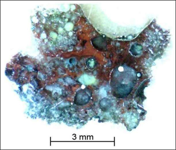
On Monday, 16 July, 1945, the atomic age began with the detonation of a plutonium bomb at the Alamogordo Bombing range. One of the products of this nuclear explosion was a green glassy material that was called trinitite, the first atomic rock. The trinitite layer had a radius of ~300 m and was ~2 cm thick. The top of the layer was glassy green while the underside was light tan with sandy inclusions. The trinitite occurs as fragments, agglomerated droplets, and 2 to 3 mm beads that are spheroidal, teardropped shaped or oblong. The original trinitite layer was bulldozed under shortly after the blast, but trinitite beads are now found at the surface around anthills.
The sand at the site is arkosic and consists of α-quartz, microcline, albite, muscovite, and actinolite. This material was entrained in the blast and melted to form trinitite. It is estimated that approximately 85% of the melted material was deposited near ground zero and formed the trinitite layer while the remainder was carried some distance downwind. Anthill trinitite has been found several 1000 m from ground zero. The only crystalline phase found in trinitite is α-quartz. The quartz occurs as fragmented and partly embayed grains. A number of glasses can be distinguished which show a wide variation in chemistry. [..]

http://faculty.uml.edu/Nelson_Eby/Research/Trinitite/Images/Trinitite%20fragments%20paper.jpg URL: http://faculty.uml.edu/Nelson_Eby/Research/Trinitite/Trinitite.htm Caption: Green trinitite fragments

IMG: http://faculty.uml.edu/Nelson_Eby/Research/Trinitite/Images/Red%20Trinitite.jpg URL: http://faculty.uml.edu/Nelson_Eby/Research/Trinitite/Trinitite.htm Caption: Red trinitite
http://faculty.uml.edu/Nelson_Eby/Research/Trinitite/Images/BEADS_SITE2_PART_B_HERMES_COLLECTION2.jpg URL: http://faculty.uml.edu/Nelson_Eby/Research/Trinitite/Trinitite.htm Caption: Trinitite beads and dumbbells

IMG: http://faculty.uml.edu/Nelson_Eby/Research/Trinitite/Images/trinitite%20pancake%20002.jpg URL: http://faculty.uml.edu/Nelson_Eby/Research/Trinitite/Trinitite.htm Pancake trinitite
http://faculty.uml.edu/Nelson_Eby/Research/Trinitite/Trinitite.htm

IMG: http://www.iamanangelchaser.com/products/trinitite_display/trinitite_close_up.jpg URL: http://www.iamanangelchaser.com/products/trinitite_display/trinitite_display.html

IMG: http://trinititesite.com/images/IMG_0011.JPG URL: http://www.disclose.tv/forum/proof-of-ancient-atomic-wars-t18719.html Caption: Alamogordo Glass 1 LBS, found at Trinity Test Site Alamogordo, Socorro County New Mexico (Product of the First Atomic Bomb) July 16, 1945

IMG: http://www.iamanangelchaser.com/products/trinitite_display/trinitite_in_situ_large.jpg URL: http://www.iamanangelchaser.com/products/trinitite_display/trinitite_display.html

IMG: http://www.s8int.com/images/trinitite.jpg URL: http://www.s8int.com/atomic1.html Caption: Olive green Trinitite formed in New Mexico as a result of atomic testing in 1945

IMG: http://upload.wikimedia.org/wikipedia/commons/thumb/7/71/Trinitite-detail2.jpg/800px-Trinitite-detail2.jpg URL: http://en.wikipedia.org/wiki/File:Trinitite-detail2.jpg

IMG: http://www.radioactiveminerals.com/templates URL: http://radioactiveminerals.com/index.php?p=p_18&sName=Trinity-Test-Site Caption: /img/3-7-2007-tr Trinitite is the name given to the glassy residue left on the desert floor after the Trinity nuclear bomb test. The glass is primarily composed of silica and feldspar that was melted by the atomic blast. It is usually a light green color, although in some cases it is other colors. initite5.jpg URL:

IMG: http://upload.wikimedia.org/wikipedia/commons/thumb/b/bd/Trinitite-pieces3.jpg/300px-Trinitite-pieces3.jpg URL: http://en.wikipedia.org/wiki/Trinitite Caption: pieces of trinitite

IMG: http://radioactiveminerals.com/files/3-7-2007-trinitite7_m.jpg URL: http://radioactiveminerals.com/index.php?p=p_18&sName=Trinity-Test-Site Caption: Trinitite from Trinity Nuclear Site, Tularosa Basin, Alamagordo, New Mexico

IMG: http://radioactiveminerals.com/files/3-7-2007-trinitite1_m.jpg URL: http://radioactiveminerals.com/index.php?p=p_18&sName=Trinity-Test-Site Caption: Trinity Nuclear Site, Tularosa Basin, Alamagordo, New Mexico

IMG: http://farm4.static.flickr.com/3343/3230949076_4d096bb90f.jpg URL: http://www.ratedesi.com/i/pic/tp7YdLL5p3d6ZM:/Stone-Middot-Rock-Middot-Glass
Trinitite – product of the first atomic bomb explosion
Trinity site, Tularosa Basin, Alamogordo, Socorro County, New Mexico, USA
Early in the morning on July 16, 1945, the first atomic bomb blast was detonated at the Trinity Site. The actual explosion produced a blast equivalent to eighteen thousand tons of TNT. The resulting fireball that scorched the desert formed a depressed crater 800 yards in diameter, glazed with a light olive green, glass-like substance where the sand had melted and solidified again. The following excerpt is from Time Magazine, Sept. 17, 1945: “Seen from the air, the crater itself seems (looks like) a lake of green Jade shaped like a splashy star, and set in a sere disc of burnt vegetation half a mile wide. From close up the lake is a glistening encrustation of blue-green glass 2,400 feet in diameter, formed when the molten soil solidified in air.” Chemical tests have confirmed that it is nearly pure melted silica with traces of Olivine, Feldspar, and other minerals which comprise the desert sand. The crater was buried for security reasons not long after the explosion and, as a result, Trinitite has remained relatively difficult to obtain.
http://www.minresco.com/trinitite/trin.htm
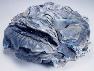
Chernobyl – Elephant’s foot

Img: http://files.abovetopsecret.com/images/member/bf822b7d3b8e.gif
The elephant’s foot was lava-like formation consisting of fused sand, reactor material and concrete.
http://www.abovetopsecret.com/forum/thread642188/pg1
Fused metal, concrete and glass

Img: http://i662.photobucket.com/albums/uu347/911conspiracytv/meteorites_side-by-side.jpg
URL: http://911conspiracy.wordpress.com/2010/01/24/molten-steel-extreme-temperatures-at-wtc/
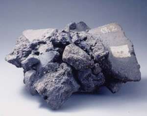
Caption: WTC “meteorites” — molten steel and concrete, etc.
Quote:
This documentary in particular draws attention to the incredible state into which building materials were contorted. The film features a unique look at one of the “meteorites” — a “fused element of steel, molten steel and concrete and all these things fused by the heat into one single element.” (Voorsanger, Ibid. Watch at http://www.youtube.com/watch?v=3SLIzSCt_cg#t=1m20s — or download the clip (mpeg2): here )
VIDEO: From “9/11- NIST engineer John Gross denies WTC molten steel (extended)”. Starts at 1 min 20 sec. Youtube
Note that “the melting point of concrete varies between 1800-2500°C” (See http://www.weldcare.co.uk/app10.htm ).
“It was like the surface of another planet. All there was, was powdered debris and metal. It was a – a very strange scene.”
– Chief Daniel Nigro (FDNY Chief of Department 2001-2) in “Conspiracy Files – 9/11: The Third Tower,” BBC TV 2008 — Youtube | Dailymotion at vrt 22:21.
VIDEO: WTC 7 – BBC The Third Tower – surface of another planet Dailymotion
URL: http://911conspiracy.wordpress.com/2010/01/24/molten-steel-extreme-temperatures-at-wtc/
Hiroshima –”Molten lava”
The areas totally collapsed and burned, totally collapsed, half collapsed and burned, and irreparably damaged spread in nearly concentric circles around the hypocenter. Within a radius of about two kilometers, the city had become scorched earth. The burnt ruins were so covered with materials melted by the extreme heat, the city appeared to have been buried in molten lava. GIF | pcf.city.hiroshima.jp
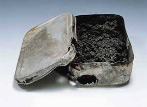
Lunchbox: 600 m from the hypocenter HiroshimaPeaceSite
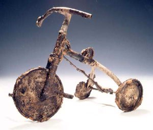
Tricycle: 1500 m from the hypocenter HiroshimaPeaceSite
Melted and fused metal found at WTC and Pentagon
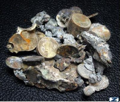
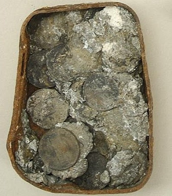
Melted and fused coins at the WTC Link
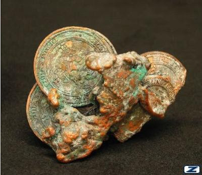
This fused clump of presentation coins and a fire-scarred medallion were recovered from the damaged offices of the Pentagon link
This burned paper currency and tin of melted coins were recovered from the damaged offices in the Pentagon. link
Video of lava-like formation: “Almost like a chunk of lava”

Still from the video: molten fused lava- like mass of concrete and steel. “Almost like a chunk of lava”.
VIDEO: http://www.youtube.com/watch?v=3SLIzSCt_cg#t=1m20s
VIDEO:From “9/11- NIST engineer John Gross denies WTC molten steel (extended)”. Starts at 1 min 20 sec. Youtube
Chernobylite
VIDEO: Robot inside Chernobyl’s Sarcophagus
Chernobylite. Both Chernobyl and Ground Zero of WTC contained masses of lava-like fused rock and metal.

A lump of lava-like chernobylite, that contains up to 10% of uranium, that was discovered at the Chernobyl reactor. It was formed from the meltdown of the core.
“Chernobylite is a technogenic mineral, a crystalline zirconium silicate with high (up to 10%) content of uranium as a solid solution. It is black and yellow. It was discovered in the corium produced in the Chernobyl accident, a lava-like glassy material formed in a nuclear meltdown of a reactor core. Chernobylite is highly radioactive due to its high uranium content and contamination by fission products.” Wikipedia
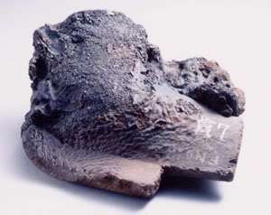
Fused compressed masses resembling meteorites were found at Ground Zero
These are evidence that a great deal of thermal energy was emitted in the explosions.
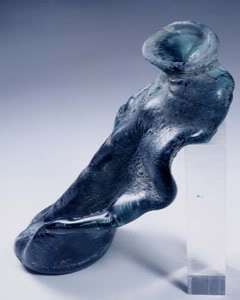
Glass a “Rare Find” at Ground Zero

Img: http://i662.photobucket.com/albums/uu347/911conspiracytv/Airplane_Fragment.jpg
“Glass shards: Glass was a rare find at Ground Zero, where these shards were recovered. The collapse and fires pulverized and melted most of the glass from the Twin Towers’ 43,600 windows.”
by metamars on Thu Jan 08, 2009 5:21 pm
“I went to the NYC Police Museum today to verify that the article and accompanying text were genuine. They are, indeed. Furthermore, there were a few shards of glass, with the following text, which I copied down:
‘Glass was a rare find at Ground Zero, where these shards were recovered. The collapse and fires pulverized and melted most of the glass from the Twin Towers 43,600 windows.’”
– http://the911forum.freeforums.org/wtc-6-molten-concrete-anomaly-t113.html
You didn’t find a shard of glass– anything that looked like it would be used by a person, you just didn’t see it. It was just concrete, steel, that was it– and dust.
– FDNY Engine 285 firefighter in “Collateral Damages” (2006, Turn of the Century Pictures, Inc.)
http://911conspiracy.wordpress.com/2010/01/24/30/
MUCH MORE FROM: http://911conspiracy.wordpress.com/2010/01/24/molten-steel-extreme-temperatures-at-wtc
Materials found melted and fused in Hiroshima
Deformed soft drink bottle
http://www.pcf.city.hiroshima.jp/virtual/cgi-bin/museum.cgi?no=3018&l=e
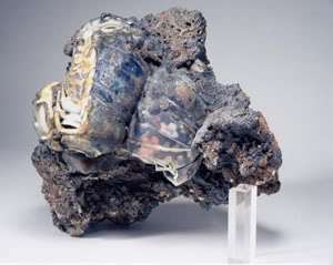
Roof Tiles
The heat of the fire partially melted these tiles and fused them like a lump of lava. Tiles melt at 1,200 to 1,300{C, which tells us how extremely hot the fire was.
http://www.pcf.city.hiroshima.jp/virtual/cgi-bin/museum.cgi?no=3020&l=e
Fused Lump of Small Glass Bottles
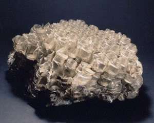
This lump of small glass bottles was dug up from the ruins of an ink factory in front of [Minoru’s] house. The bottles were fused into a lump by the fire. When he saw it, Minoru mumbled, “Must have been really hot.”
http://www.pcf.city.hiroshima.jp/virtual/cgi-bin/museum.cgi?no=3027&l=e
![]()
http://www.jason-webb.com/cool-japanese-culture/images/hiroshima_peace_memorial_museum_L19.jpg URL: http://www.jason-webb.com/cool-japanese-culture/hiroshima_peace_memorial_museum.html Caption: This stack of small glass bottles was melted and fused together by the heat from the atomic bomb blast. Hiroshima Peace Memorial Museum. By Jason Webb.
http://www.jason-webb.com/cool-japanese-culture/hiroshima_peace_memorial_museum.html
Roof tiles
These roof tiles were partially melted by the intense heat. The melting point of roof tiles is 1,200 to 1,300℃. Thus, these tiles are evidence of an abnormally hot fire.
http://www.pcf.city.hiroshima.jp/virtual/cgi-bin/museum.cgi?no=3030&l=e
Fused lump of pottery and roof tiles
http://www.pcf.city.hiroshima.jp/virtual/cgi-bin/museum.cgi?no=3032&l=e
Fused lump of plates and glass
http://www.pcf.city.hiroshima.jp/virtual/cgi-bin/museum.cgi?no=3069&l=e
Underground nuclear explosion
Image: http://upload.wikimedia.org/wikipedia/commons/b/b6/Sedan_Plowshare_Crater.jpg URL: http://en.wikipedia.org/wiki/Operation_Plowshare Capture: The 1962 “Sedan” plowshares shot displaced 12 million tons of earth and created a crater 320 feet (100 m) deep and 1,280 feet (390 m) wide. [More information: This is a blast crater rather than a subsidence crater.]
Underground explosion
Deep Underground Explosion Phenomena – from Trinity Atomic Web Site
2.101 A deep underground explosion is one occurring at such a depth that the effects are essentially fully contained. The surface above the detonation point may be disturbed, e.g., by the formation of a shallow subsidence crater or a mound, and ground tremors may be detected at a distance. There is no significant venting of the weapon residues to the atmosphere, although some of the noncondensable gases present may seep out gradually through the surface. The United States has conducted many deep underground tests, especially since September 1961. Almost all of the explosion energy has been contained in the ground, and, except in the few cases of accidental venting or seepage of a small fraction of the residues, the radioactivity from these explosions has also been confined. The phenomena of deep underground detonations can be described best in terms of four phases having markedly different time scales.
2.102 First, the explosion energy is released in less than one-millionth part of a second, i.e., less than one microsecond (¤ 1.54 footnote). As a result, the pressure in the hot gas bubble formed will rise to several million atmospheres and the temperature will reach about a million degrees within a few microseconds. In the second (hydrodynamic) stage, which generally is of a few tenths of a second duration, the high pressure of the hot gases initiates a strong shock wave which breaks away and expands in all directions with a velocity equal to or greater than the speed of sound in the rock medium. During the hydrodynamic phase, the hot gases continue to expand, although more slowly than initially, and form a cavity of substantial size. At the end of this phase the cavity will have attained its maximum diameter and its walls will be lined with molten rock. The shock wave will have reached a distance of some hundreds of feet ahead of the cavity and it will have crushed or fractured much of the rock in the region it has traversed. The shock wave will continue to expand and decrease in strength eventually becoming the “head” (or leading) wave of a train of seismic waves (¤ 6.19). During the third stage, the cavity will cool and the molten rock material will collect and solidify at the bottom of the cavity.
2.103 Finally, the gas pressure in the cavity decreases to the point when it can no longer support the overburden. Then, in a matter of seconds to hours, the roof falls in and this is followed by progressive collapse of the overlying rocks. A tall cylinder, commonly referred to as a “chimney,” filled with broken rock or rubble is thus formed (Fig. 2.103). If the top of the chimney does not reach the ground surface, an empty space, roughly equivalent to the cavity volume, will remain at the top of the chimney. However, if the collapse of the chimney material should reach the surface, the ground will sink into to the empty space thereby forming a subsidence crater (see Fig. 6.06f). The collapse of the roof and the formation of the chimney represented the fourth (and last) phase of the underground explosion.

Figure 2.103. The rubble chimney formed after collapse of the cavity in a deep underground nuclear detonation.
Img: http://www.cddc.vt.edu/host/atomic/images/enw77b25s.gif URL: http://www.cddc.vt.edu/host/atomic/nukeffct/enw77b2.html Caption
2.104 The effects of the RAINIER event of Operation Plumbbob in 1957 will provide an example of the extent to which the surrounding medium may be affected by a deep underground detonation. RAINIER was a 1.7-kiloton nuclear device detonated in a chamber 6 x 6 x 7 feet in size, at a depth of 790 feet below the surface in a compacted volcanic-ash medium referred to geologically as “tuff.” During the hydrodynamic stage the chamber expanded to form a spherical cavity 62 feet in radius, which was lined with molten rock about 4 inches thick. The shock from the explosion crushed the surrounding medium to a radius of 130 feet and fractured it to 180 feet. Seismic signals were detected out to distances of several hundred miles and a weak signal was recorded in Alaska. The chimney extended upward for about 400 feet from the burst point.
http://www.cddc.vt.edu/host/atomic/nukeffct/enw77b2.html
Factfile: Underground nuclear testing – From BBC News
Nuclear devices are often tested underground to prevent radioactive material released in the explosion reaching the surface and contaminating the environment.
This method also ensures a degree of secrecy.
The release of radiation from an underground nuclear explosion – an effect known as “venting” – would give away clues to the technical composition and size of a country’s device, and therefore its nuclear capability.
STAGES OF AN UNDERGROUND NUCLEAR TEST

http://news.bbc.co.uk/nol/shared/bsp/hi/dhtml_slides/09/n_korea_test/img/slide01.gif URL: http://news.bbc.co.uk/2/hi/asia-pacific/6033893.stm Caption:
1. Preparation: a hole is drilled, the device set and then the tunnel plugged.
1. Preparation: a hole is drilled, the device set and then the tunnel plugged.

http://news.bbc.co.uk/nol/shared/bsp/hi/dhtml_slides/09/n_korea_test/img/slide02.gif URL: http://news.bbc.co.uk/2/hi/asia-pacific/6033893.stm Caption: 2. Detonation: the device is detonated from the control room.
2. Detonation: the device is detonated from the control room.

http://news.bbc.co.uk/nol/shared/bsp/hi/dhtml_slides/09/n_korea_test/img/slide03.gif URL: http://news.bbc.co.uk/2/hi/asia-pacific/6033893.stm Caption: 3. Aftermath: the gas cools and the chamber collapses producing a crater.
3. Aftermath: the gas cools and the chamber collapses producing a crater.
Preparation
The test site is carefully geologically surveyed to ensure suitability. Such tests usually take place well away from population centres.
The nuclear device is placed into a drilled hole or tunnel usually between 200-800m (650-2,600ft) below the surface, and several metres wide.
A lead-lined canister containing monitoring equipment is lowered into the shaft above the chamber. The hole is then plugged with gravel, sand, gypsum and other fine materials to contain the explosion and fallout underground.
The test
http://newsimg.bbc.co.uk/media/images/45825000/jpg/_45825538_nuclearseizemic_226afp.jpg URL: http://news.bbc.co.uk/2/hi/asia-pacific/6033893.stm Caption: Seismic shockwaves from the latest test were recorded in South Korea
The device is remotely detonated from a surface control bunker. The nuclear explosion vaporises subterranean rock, creating an underground chamber filled with superheated radioactive gas.
As this cools, a pool of molten rock collects at the bottom of the chamber.
Minutes or hours later, as pressure falls, the chamber collapses in on itself causing subsidence and a crater to appear on the surface.
http://news.bbc.co.uk/2/hi/asia-pacific/6033893.stm
Lake Chagan
Pictures of Lake Chagan formerly a crater

http://sonicbomb.com/albums/album08/chagan1_001.jpg URL: http://sonicbomb.com/modules.php?set_albumName=album08&id=chagan1_001&op=modload&name=gallery&file=index&include=view_photo.php Caption: Date: 06:00 UTC 15/01/1965
Type: Subsurface @-178m
Yield: 140 Mt
Chagan was the USSR’s first Peaceful Nuclear Explosion (PNE), the purpose being to gather data on the use of nuclear explosives for industrial purposes. A 140 kiloton low-fission thermonuclear device utilised a pure fusion secondary and a 5-7 kiloton fission primary. The test was situated in the Chagan River dry bed so that the crater lip that would be formed by the explosion would serve as a dam during the Spring high flow. The explosion formed a crater 400 meters in diameter and 100 meters deep. A lake was formed behind the 34 meter upraised lip. Earthmoving equipment then cut a channel through the lip allowing the river to enter the crater filling it with 12 billion litres of water. The reservoir was named Lake Chagan also known as Lake Balapan or the “Atomic Lake”. Approximately 20% of the fission products released by the Chagan test escaped into the atmosphere, with dose levels at the crater lip of 20-30 R/hr. While the test did not violate the 1963 Limited Test Ban Treaty (it was an underground test), radiation was later detected over Japan. Today, the dose level on the lip is reported to be ~2.6 mR/hr. Beyond a restricted area 100-150 m from the lip, the dose rate is at background levels.

http://nuclearweaponarchive.org/Russia/Chagan3.jpg URL: http://nuclearweaponarchive.org/Russia/Sovwpnprog.html#Chagan Caption: The nuclear explosive used for the Chagan test was reported to be a low-fission design, which had a pure thermonuclear secondary driven by a fission primary with a yield of about 5-7 kt. Approximately 20% of the radioactive products of the explosion escaped into the atmosphere, resulting in dose levels on the lip of the crater of 20-30 R/hr several days after the explosion, most of which was from Co 60 (5.26 year half-life). Today, the dose level on the lip is reported to be ~2.6 mR/hr. Beyond a restricted area 100-150 m from the lip, the dose rate is at background levels (15-20 microR/hr). Radioactivity levels in the lake water in the crater are reported to be about 300 pCi/liter.

http://maps.pomocnik.com/img/Jezioro-Chagan-w-kraterze-poat.jpg URL: http://maps.pomocnik.com/lake-chagan-nuclear-crater-kazakhstan/ Caption: Lake Chagan, created by a Soviet nuclear test – the site for the Chagan shot was the dry bed of the Chagan River on the edge of the Semipalatinsk Test Site (STS) in Kazakhstan. The shot location was chosen so that the crater lip would form a dam in the river during its period of high flow in the spring. The crater formed by the Chagan explosion had a diameter of 408 m and a depth of 100 m. A major lake (10,000,000 m 3 ) was quickly formed behind the 20-35 m high upraised lip. Shortly after the explosion, earthmoving equipment was used to cut a channel through the lip so that water from the river could enter the crater.

http://www.google-earth.es/uploads/forums/thumbs/t_lago_chagan.jpg URL: http://www.google-earth.es/foros.php?p=27940 Caption: Lake Chagan

Screen capture from here: http://virtualglobetrotting.com/map/lake-chagan-created-by-a-soviet-nuclear-test-explosion/view/?service=0 Caption: Lake Chagan

http://mw2.google.com/mw-panoramio/photos/medium/16460006.jpg
URL: http://www.panoramio.com/photo/16459939

http://nuclearweaponarchive.org/Usa/Tests/RanierChimney849.gif URL: http://nuclearweaponarchive.org/Usa/Tests/Plumbob.html Caption: Test: Rainier
Time: 16:59.59.5 19 September 1957 (GMT)
Location: NTS, Area 12
Test Height and Type: Tunnel shot, depth -899 feet
Yield: 1.7 kt
UCRL deep underground test shot to evaluate containment and detection of underground nuclear tests. Fired in B-tunnel in side of Ranier Mesa.
My comment: See the puddle of radioactive glass at the bottom of the cavity.

http://nuclearweaponarchive.org/Library/Effects/Craters1024c30.jpg URL: http://nuclearweaponarchive.org/India/IndiaRealYields.html Caption: different types of surface phenomena seen at various burst depths scaled to one kiloton

http://nuclearweaponarchive.org/Library/Effects/CraterDiag2_640.gif URL: http://nuclearweaponarchive.org/India/IndiaRealYields.html Caption: In a shallow underground explosion the cavity formation goes through phases as depicted in [Teller et al 1968, p. 143]: [Teller et al 1968] Edward Teller, Wilson K. Talley, Gary H. Higgins, Gerald W. Johnson. 1968. The Constructive Uses of Nuclear Explosives, McGraw-Hill Book Co., LC 68-11621.
Formation of craters
![]()
TIFF from: http://www.fas.org/sgp/othergov/doe/lanl/osti/671858.pdf URL: http://www.fas.org/sgp/othergov/doe/lanl/osti/671858.html Caption: DOE Title Surface effects of underground nuclear explosions
Creator/Author Allen, B.M.; Drellack, S.L. Jr.; Townsend, M.J.
Publication Date 1997 Jun 01

TIFF from: http://ny.curbed.com/archives/2009/08/20/wtc_slapfight_update_port_authority_finally_finishing_up.php Caption: August 14, 2009 East Bathtub

http://4.bp.blogspot.com/_VyTCyizqrHs/SJoa3O7roFI/AAAAAAAABEQ/phYJ1RFvn14/s1600-h/nynuke.jpg Don’t know URL

http://graphics8.nytimes.com/images/2008/09/22/nyregion/22rocks_650.jpg URL: http://www.nytimes.com/2008/09/22/nyregion/22rocks.html?_r=3&ref=nyregion&oref=slogin Caption: David W. Dunlap/The New York Times Excavation at the World Trade Center site has uncovered, among other geologic features, a 40-foot glacial pothole .. A fantastic landscape in Lower Manhattan — plummeting holes, steep cliffsides and soft billows of steel-gray bedrock, punctuated by thousands of beach-smooth cobblestones in a muted rainbow of reds and purples and greens — has basked in sunlight this summer for the first time in millennia.
Caption: Red trinitite IMG: http://faculty.uml.edu/Nelson_Eby/Research/Trinitite/Images/Red%20Trinitite.jpg URL: http://faculty.uml.edu/Nelson_Eby/Research/Trinitite/Trinitite.htm

http://graphics8.nytimes.com/images/2008/09/22/nyregion/22rocks_650.jpg URL: http://www.nytimes.com/2008/09/22/nyregion/22rocks.html?_r=3&ref=nyregion&oref=slogin Caption: David W. Dunlap/The New York Times Excavation at the World Trade Center site has uncovered, among other geologic features, a 40-foot glacial pothole .. A fantastic landscape in Lower Manhattan — plummeting holes, steep cliffsides and soft billows of steel-gray bedrock, punctuated by thousands of beach-smooth cobblestones in a muted rainbow of reds and purples and greens — has basked in sunlight this summer for the first time in millennia. My comment: See the puddle of melted glass formed.

http://graphics8.nytimes.com/images/2008/09/22/nyregion/22rocks_650.jpg URL: http://www.nytimes.com/2008/09/22/nyregion/22rocks.html?_r=3&ref=nyregion&oref=slogin Caption: David W. Dunlap/The New York Times Excavation at the World Trade Center site has uncovered, among other geologic features, a 40-foot glacial pothole .. A fantastic landscape in Lower Manhattan — plummeting holes, steep cliffsides and soft billows of steel-gray bedrock, punctuated by thousands of beach-smooth cobblestones in a muted rainbow of reds and purples and greens — has basked in sunlight this summer for the first time in millennia.

http://upload.wikimedia.org/wikipedia/en/a/ae/Subsidence_crater.jpg URL: http://en.wikipedia.org/wiki/Subsidence_crater
Caption: Post-shot subsidence crater and Huron King test chamber, which was less than 20 kilotons (1980) IMG 2: Img 2: http://graphics8.nytimes.com/images/2008/09/22/nyregion/22rocks_650.jpg URL: http://www.nytimes.com/2008/09/22/nyregion/22rocks.html?_r=3&ref=nyregion&oref=slogin Caption: David W. Dunlap/The New York Times
http://upload.wikimedia.org/wikipedia/en/a/ae/Subsidence_crater.jpg URL: http://en.wikipedia.org/wiki/Subsidence_crater
Caption: Post-shot subsidence crater and Huron King test chamber, which was less than 20 kilotons (1980)

Img 2: http://graphics8.nytimes.com/images/2008/09/22/nyregion/22rocks_650.jpg URL: http://www.nytimes.com/2008/09/22/nyregion/22rocks.html?_r=3&ref=nyregion&oref=slogin Caption: David W. Dunlap/The New York Times. Excavation at the World Trade Center site has uncovered, among other geologic features, a 40-foot glacial pothole. IMG 2: http://bp1.blogger.com/_osrVjnPbdEM/SIXgyEiWUdI/AAAAAAAACz0/EHbpoNoB4W8/s400/Underground_Nuclear_Explosion_2.jpg URL: http://www.popgive.com/2008/07/underground-nuclear-explosion.html Caption: Underground nuclear explosion. Crater is The result of massive underground explosions by the U.S. Atomic Energy Commission during Operation Dugout in 1960.

IMG: http://i746.photobucket.com/albums/xx108/phtobkt325/408.jpg URL: http://forums.dhsdiecast.com/default.aspx?g=posts&m=1112833 Caption: by a forum poster (Cat 966f) about fall 2010.

IMG: http://i746.photobucket.com/albums/xx108/phtobkt325/392.jpg URL: http://forums.dhsdiecast.com/default.aspx?g=posts&m=1112833 Taken by a forum poster (Cat 966f) about fall 2010.
Mushrooms

Caption: This is the basement of the WTC complex, early Feb. 2002 IMG: http://web.archive.org/web/20021212003844/wtcgodshouse.com/images/basement.jpg URL: http://web.archive.org/web/20021211182244/http://www.wtcgodshouse.com/photos.html
Caption: Lower Manhattan on September 15, 2001. Image provided by spaceimaging.com. IMG: http://www.planetizen.com/files/oped/20010917smallmanhattan0915.jpg URL: http://www.planetizen.com/node/27
http://drjudywood.com/articles/DEW/StarWarsBeam4.html
IMG URL: http://www.911research.com/wtc/evidence/photos/docs/ground_zero_arial_s.jpg URL: http://www.911research.com/wtc/evidence/photos/groundzero.html Caption: Satellite photo of Ground Zero
http://www.noaanews.noaa.gov/stories/s798b.htm (moved)
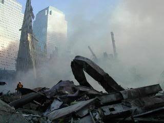
http://www.911research.com/wtc/evidence/photos/docs/dscn_0332.jpg URL: http://www.911research.com/wtc/evidence/photos/gzimmed2.html
More from: http://www.911research.com/wtc/evidence/photos/groundzero.html
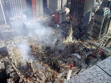
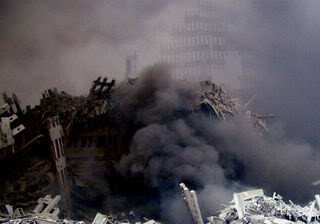
http://www.911research.com/wtc/evidence/photos/docs/wtc_shattered2.jpg URL: http://www.911research.com/wtc/evidence/photos/gzimmed1.html Caption: A Photo of Ground Zero Soon After the Attack
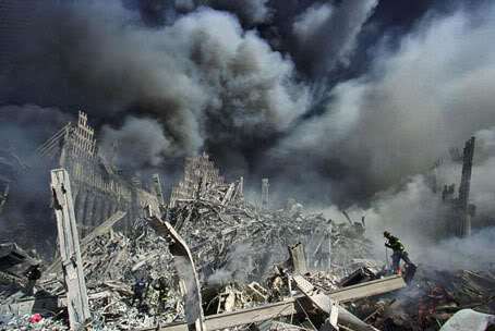
http://www.911research.com/wtc/evidence/photos/docs/gz_hd1391p50.jpg URL: http://www.911research.com/wtc/evidence/photos/gzrescue2.html
More photos of GZ from: http://www.911research.com/wtc/evidence/photos/groundzero.html
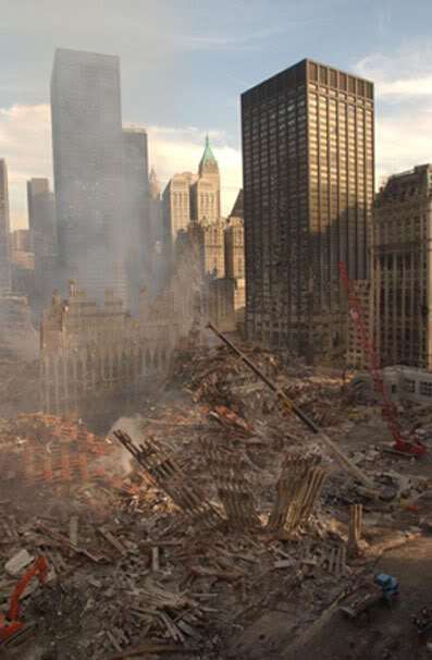
http://www.911research.com/wtc/evidence/photos/docs/oem/9_18_pic08.jpg URL: http://www.911research.com/wtc/evidence/photos/oem4.html
http://www.911research.com/wtc/evidence/photos/groundzero.html
http://www.911research.com/wtc/evidence/photos/docs/wtc_cross.jpg URL: http://www.911research.com/wtc/evidence/photos/gzimmed3.html My caption: The remains of the WTC.
http://www.911research.com/wtc/evidence/photos/groundzero.html
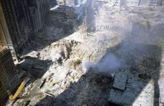
http://www.911research.com/wtc/evidence/photos/docs/jc/jc_234.jpg URL: http://www.911research.com/wtc/evidence/photos/gzelev2.html Caption: Photos of GZ from Cortland Street.
http://www.911research.com/wtc/evidence/photos/groundzero.html
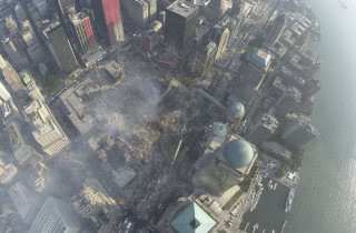
http://www.911research.com/wtc/evidence/photos/docs/oem/9_22_pic03.jpg URL: http://www.911research.com/wtc/evidence/photos/oem7.html Caption: Photos from 9/22/01. Aerial Photos of Ground Zero Provided by New York City’s Office of Emergency Management. These photographs, from 9/22/01 show Ground Zero from over 1000 feet aloft. They show the positions of several cranes.
http://www.911research.com/wtc/evidence/photos/groundzero.html
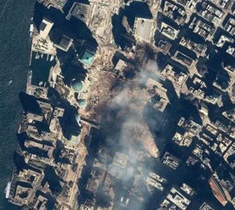
http://www.911research.com/wtc/evidence/photos/docs/ground_zero_arial.jpg URL: http://www.911research.com/wtc/evidence/photos/gzaerial1.html
http://www.911research.com/wtc/evidence/photos/groundzero.html
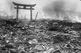
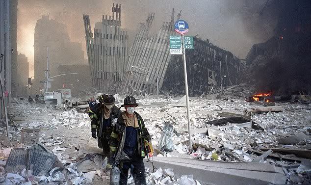
Caption: In memory: Firefighters walk through the shattered remains of the World Trade Center after the terrorist atrocity in 2001 IMG: http://i.dailymail.co.uk/i/pix/2010/02/05/article-1248679-02FEECA80000044D-953_634x377.jpg URL: http://www.dailymail.co.uk/news/worldnews/article-1248679/First-pictures-construction-1-World-Trade-Centre-reaches-200ft.html
Hiroshima – wasted landscape
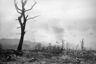
http://www.pcf.city.hiroshima.jp/virtual/img/ex0607_img/000.jpg URL: http://www.pcf.city.hiroshima.jp/virtual/VirtualMuseum_e/exhibit_e/exh0607_e/exh060701_e.html
East of hypocenter (Hiroshima)
Taken 1.4km east of the hypocenter URL: http://www.pcf.city.hiroshima.jp/kids/KPSH_E/hiroshima_e/sadako_e/subcontents_e/09sadakohibaku_4_e.html
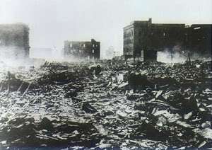
Taken 500 meters east of the hypocenter (7 August, 1945) IMG: http://www.pcf.city.hiroshima.jp/virtual/img/panel_img/3107.jpg URL: http://www.pcf.city.hiroshima.jp/virtual/VirtualMuseum_e/visit_e/est_e/panel/A3/3107.htm

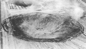
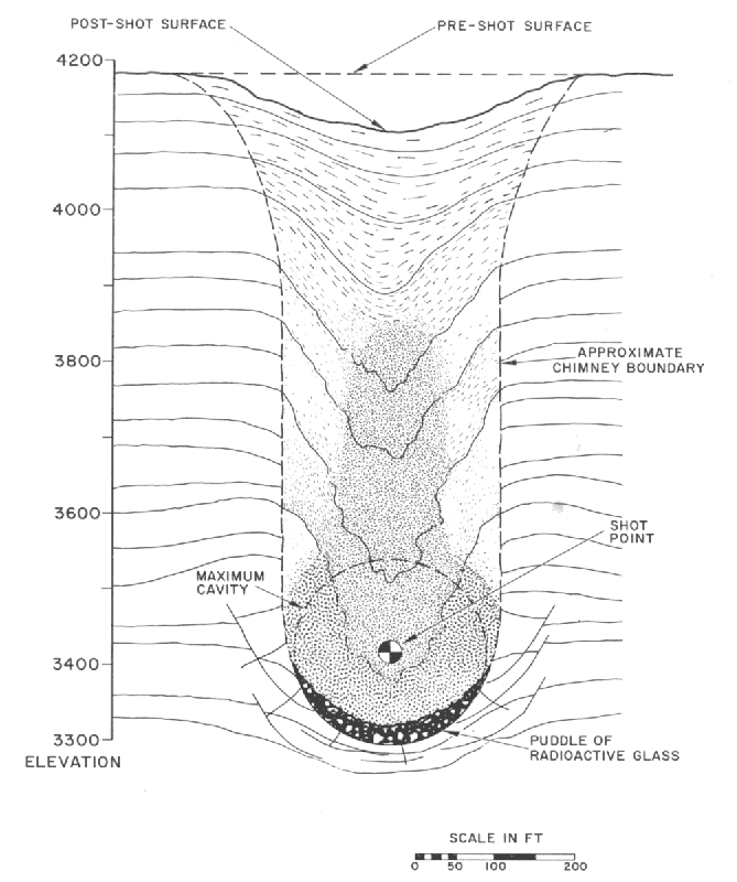
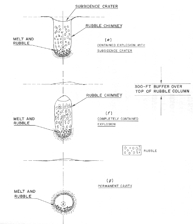
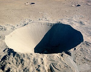
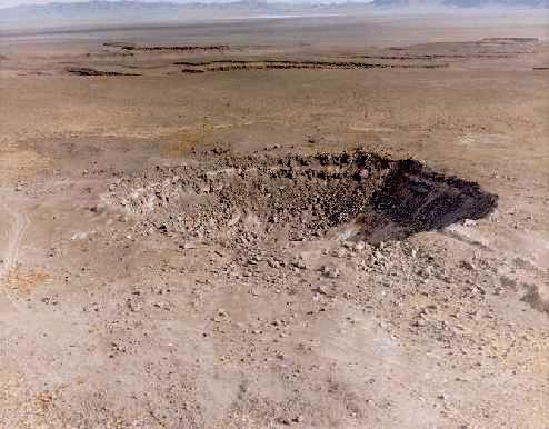
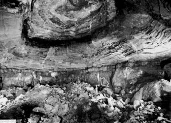
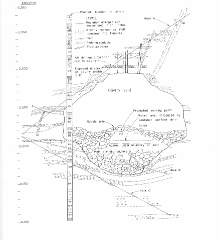
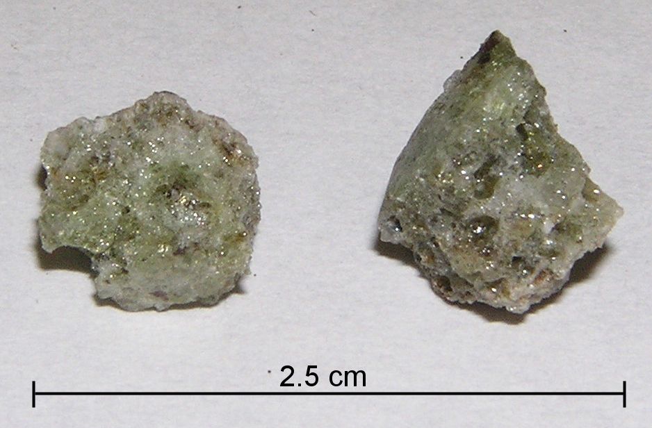
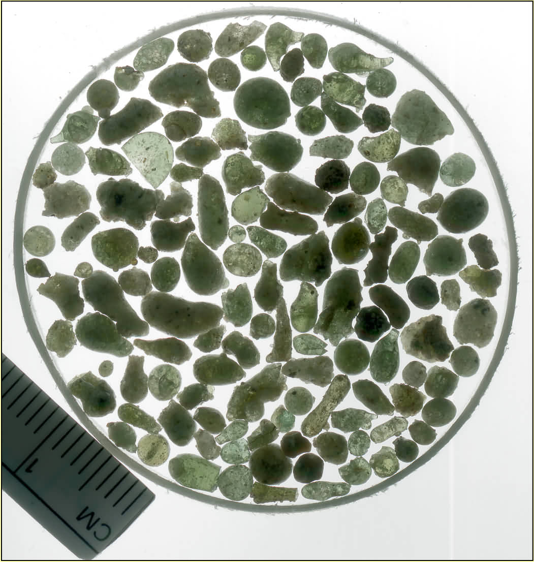
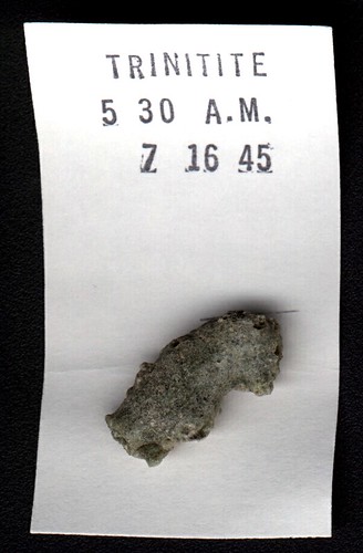
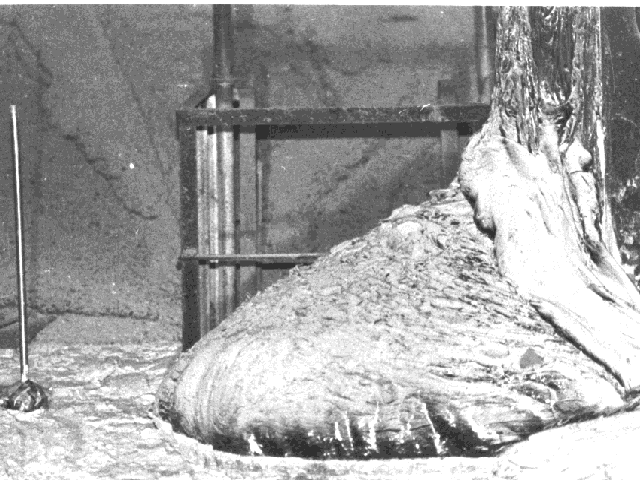
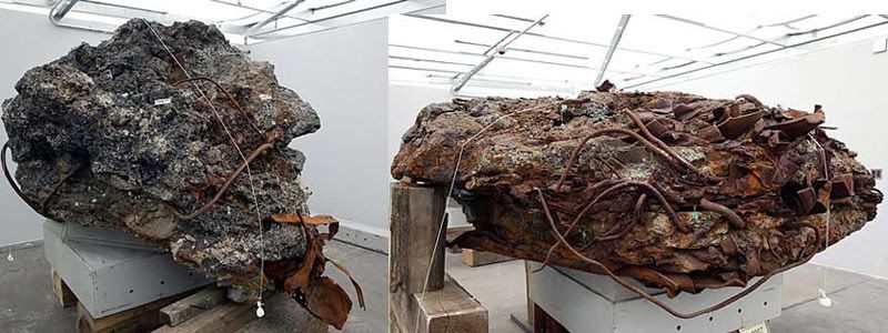
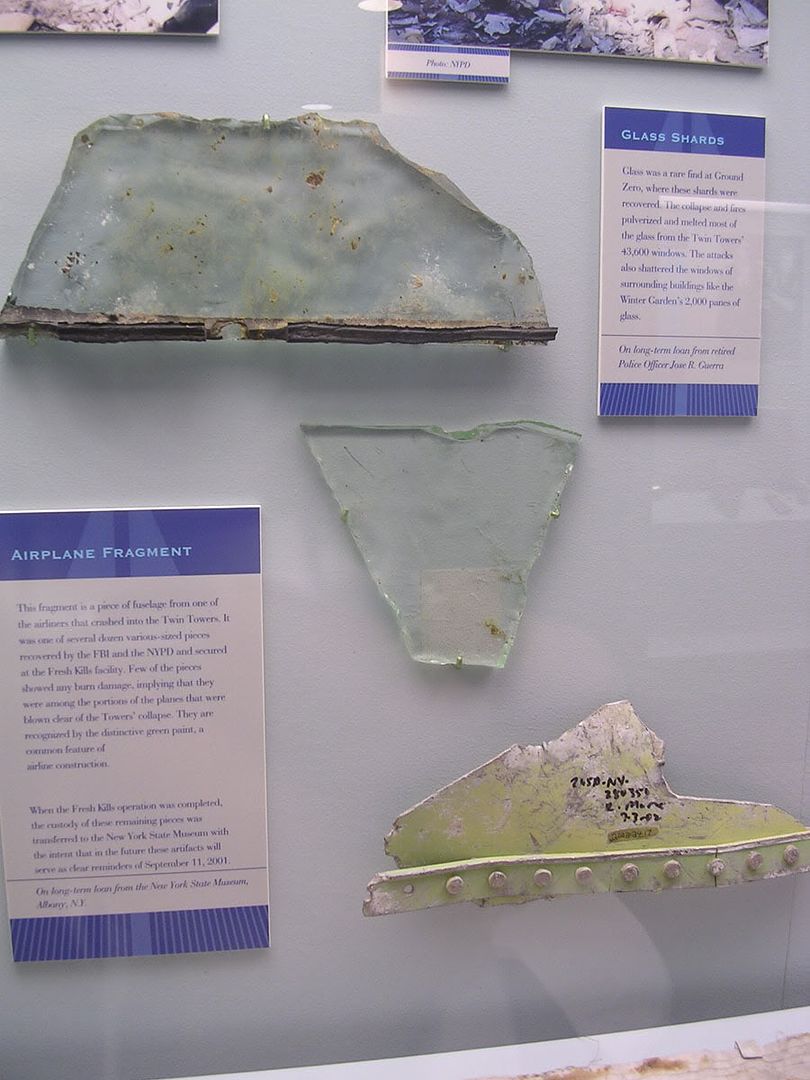
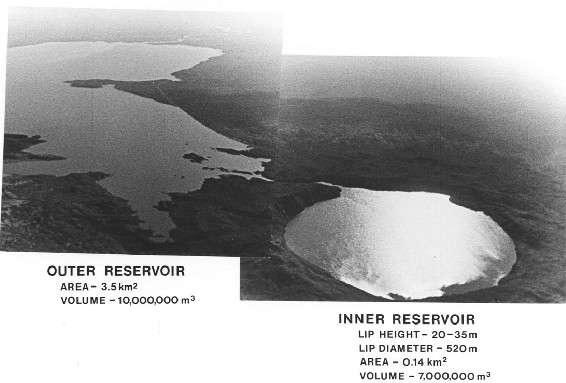
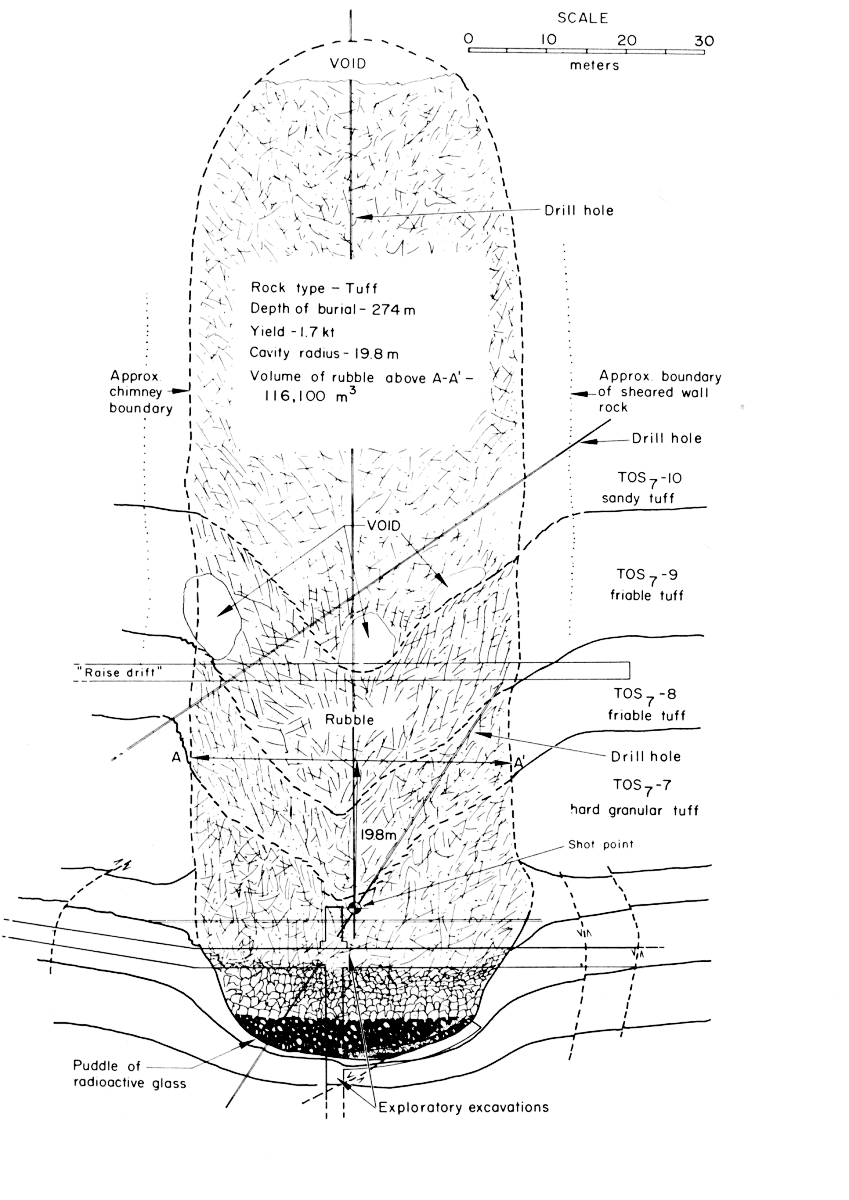
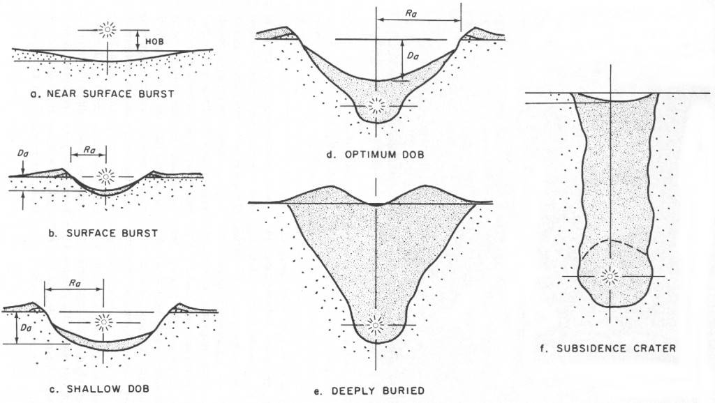
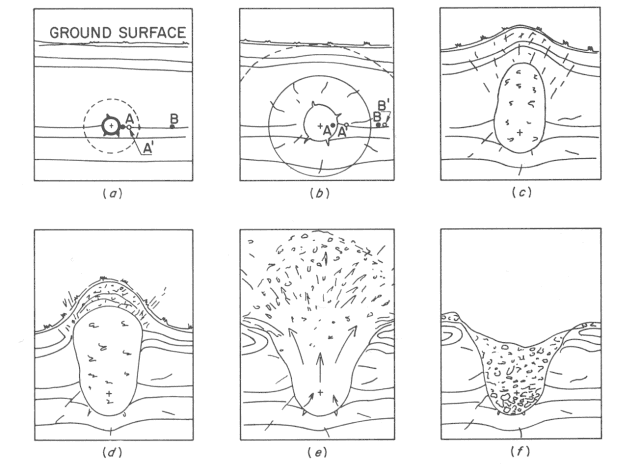
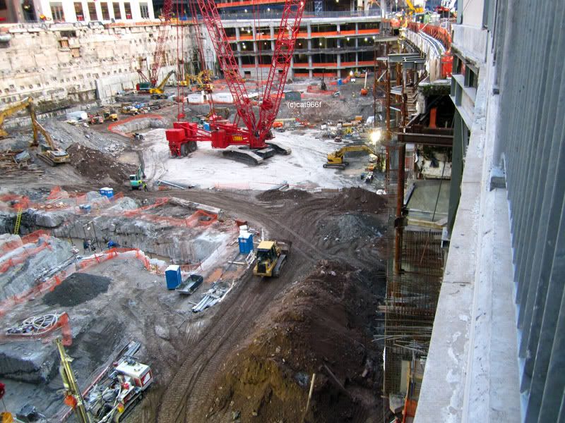