There were elevated levels of radiation found in Staten Island according to one media source about the survey performed by the Government Accounting Office that was done using a helicopter equipped with radiation detection equipment and computers, in 2005, in an effort to establish baseline radiation levels, in case of a terrorist dirty bomb attack in the future.
A radiological survey of the city conducted by the Department of Energy on behalf of the New York Police Department uncovered an area in Fresh Kills Park on Staten Island with high levels of radium, according to a report released yesterday by the Government Accountability Office.
In the same report, it says that the NYPD found old radiological equipment in a one-acre area of “the park”, and they believed this to be the source of radiation. A later report says this radiological equipment was found in Great Kills Park.
Investigators found small pieces of rusted metal — possibly remnants of industrial equipment — that had presumably been dumped in the park before it was taken over from the city by the National Park Service in 1972, a spokesman for the National Park Service, Brian Feeney, said.
The source and location of the radiation hot spots is confounded further with the report that in April 2016, 1,200 hot spots in total had been found “across the park” in a radiation survey performed in 2015.
A later National Park Service survey found more than 1,200 radioactive areas across the park (2015).
Both Fresh Kills and Great Kills had been used as landfills.
Between 1944 to 1948 the city used about 15 million cubic yards of fill and and waste to increase usable land at Great Kills
The report about the radiation survey that was done in 2015 goes on to to say that:
“More than three decades passed before elevated levels of radioactivity were first found at the park, during an NYPD flyover conducted as part of a counterterrorism search.”
However, it’s not clear whether this refers to Great Kills Park or Fresh Kills Park.
GAO has never publicly identified the exact locations of the radioactive locations found in Staten Island.
It is more likely that a park that had received more than a million tons of debris in 2001 to be the source of the radiation than a park which had debris dumped in it in the 40s.
The Department of Energy had been paid $800,000 by New York Police Department to do the survey. Most of the money paid by the NYPD had been given to it by the Department of Homeland Security.
The vagueness of the government report, with no complete report of locations and measurements recorded, in a study that cost $800,000, is very curious.
In another report, it states that:
Anti-terrorism officials conducted a helicopter survey of New York City’s radiation sources in preparation for a so-called “dirty bomb” attack — and discovered a Staten Island park with dangerously high levels of radium, a new report found.
The article goes on further to say that:
The report does not identify which city park had the contaminated soil, but NYPD officials said it was in Gateway National Park in Staten Island.
The report says that “dozens” of unexpected hot spots of radioactivity had been found.
The helicopters picked up sources of low-level radiation from expected places, like granite statues and medical isotopes at hospitals, but it also found dozens of other sources of unexpected radioactivity, the GAO report found.
A second area of radiation was found in Great Kills Park in 2007, about a quarter of a mile from the first one. The level of radiation was low: about one-sixth of the level of the first one.
In another radiation survey, this time in 2013, many more radiation hot spots were discovered in Great Kills Park. However, the level of radiation was quite small.
Then in 2015, two years later, it was determined that there were 1,200 radiation hot spots in the park. The level of radiation was not reported. The total assessment will take 5 years, according to the report.
It would be greatly in the interests of the perpetrators for any radioactivity found at Fresh Kills to not be reported, since such a discovery would make people wonder if the radioactivity was related to September 11.
So far one report has come out mentioning Fresh Kills, but the reports that followed of further studies done in that area say that the radiation hot spots were in Great Kills. And the areas that are radioactive appear to be multiplying and becoming more widespread.
This may have been due to planting of radiological material in Great Kills Park in anticipation of the radiation surveys to lead investigators away from Fresh Kills.
Most of the steel from the WTC was carted off to China for recycling. Some beams were put into museums.
The rest of the debris, about 1 million tons, remains buried under mounds of earth, forming two hills. LINK
Directly after the World Trade Center attacks, debris from the site was carted off to Staten Island’s Fresh Kills landfill. And there it sits, nearly seven years later, on the 48 acres that are called Hills 1 and 9. The hills contain household trash and about 1 million tons of World Trade Center material — including 200,000 tons from the first 32 days after the attacks that we believe was never sifted. NY Daily News
Once more, the possibility of sabotage of the investigations should not be dismissed. Certain persons who were determined that radiation at Fresh Kills landfill would not be reported or overshadowed by other news, may have planted material that gave off significant levels of radioactivity in places that were not in Fresh Kills landfill park or close to it, but on the other side of the island, and so probably chose Great Kills as this location. Periodically, other radioactive materials could have been placed in the Great Kills park, intending to draw the media’s and public’s attention toward Great Kills. A finding of radiation hot spots, especially if they were located in the hills where the WTC debris was buried, would raise concerns that the radiation came from the WTC, and might lead to discovery that the WTC had been the site of a nuclear event that released radiation.
In addition, the possibility of corruption and collusion in a cover up at the NYPD cannot be discounted.
In this former NYPD detective’s account of his experiences of working on pedophilia cases, it is reported that higher echelons of the NYPD shut down pedophilia investigations, including ones that involved the murder of children. This could have been done to cover up the pedophile activities of powerful and influential people and to hide the hand of other people in the homicide of these children.

From New York Sun:
Elevated Levels of Radium Found in Area of Fresh Kills
By BRADLEY HOPE, Staff Reporter of the Sun | September 22, 2006
A radiological survey of the city conducted by the Department of Energy on behalf of the New York Police Department uncovered an area in Fresh Kills Park on Staten Island with high levels of radium, according to a report released yesterday by the Government Accountability Office.
The NYPD paid the Department of Energy about $800,000 — most of it in the form of grants from the Department of Homeland Security — to conduct the survey in August 2005 so the city would have a radiological baseline against which future surveys could be tested. The baseline could help the city discover suspicious spikes in radiological activity such as would be associated with the construction of a “dirty bomb,” the report says. The survey found 80 hotspots in the city, but the one-acre section of the park, which is part of the Gateway National Recreation Area, was singled out for an investigation by the Department of Energy and the Environmental Protection Agency.
Investigators found small pieces of rusted metal — possibly remnants of industrial equipment — that had presumably been dumped in the park before it was taken over from the city by the National Park Service in 1972, a spokesman for the National Park Service, Brian Feeney, said. The Environmental Protection Agency recommended a more in-depth survey be done of the area, but did not identify any immediate health risks, he said.
“The public has never been allowed in that area,” Mr. Feeney said. “You couldn’t walk into this area if you wanted to. You would have to cut your way into this.”
The radiological survey, conducted by a helicopter outfitted with radiation equipment and computers, was the first such survey conducted of a major American city.Yesterday’s report advocated the wider use of the surveys to help prevent terrorist attacks, and also to have data that would be helpful in aftermath of a nuclear attack.
Rep. Vito Fossella, a Republican of Staten Island, is planning a meeting between city and state agencies “to develop a plan of action to test the area, learn the extent of the contamination, and remediate it if it poses a public health risk,” he said in a statement.
Lastly, the possibility of a cover-up by people within the ranks of the authorities, such as the NYPD, cannot be discounted. Misreporting and misrepresentation as well as collusion in planting evidence may have been done, in order to confound the findings, and prevent discovery and disclosure of radiation at Fresh Kills.
If it were known that radioactivity was found at Fresh Kills, the political implications of that would be, indeed, great. Radioactivity would immediately cause people to suspect that nuclear weapons had been used in the attacks at the World Trade Center, and would quickly lead to the discovery of the actual cause of the collapses of the building by the public.
The NYPD is no stranger to corruption allegations made against it. In this report about pedphilia, there are allegations by a former NYPD detective that murder cases involving child victims in pedophilia cases and pedophilia rings were stopped prematurely by upper echelons of the NYPD.
______________________________________________________________

|
Feds Survey City for Radiation, by AP (edit@brooklyneagle.net), published online 09-25-2006
Unexplained Radium Found in Soil; Exact Location Not Disclosed NEW YORK (AP) — Anti-terrorism officials conducted a helicopter survey of New York City’s radiation sources in preparation for a so-called “dirty bomb” attack — and discovered a Staten Island park with dangerously high levels of radium, a new report found. Federal authorities found 80 unexpected “hot spots” around New York City, according to the Government Accountability Office, the investigative arm of Congress. The GAO report yesterday released details a previously undisclosed aerial anti-terrorism program in New York City, one which may be extended to other cities worried about the possible release of radioactive material by terrorists. The report does not identify which city park had the contaminated soil, but NYPD officials said it was in Gateway National Park in Staten Island. The site was closed, and New York has requested federal money to do a citywide aerial survey every year to update the information. By creating a map of the city’s radiation sources, city officials hope to be able to respond more quickly in the event of a dirty bomb attack, know exactly which streets are contaminated and get civilians away. New York is the first and only U.S. city to conduct a complete aerial radiological survey, having paid the U.S. Department of Energy $800,000 for the 2005 study. The helicopters picked up sources of low-level radiation from expected places, like granite statues and medical isotopes at hospitals, but it also found dozens of other sources of unexpected radioactivity, the GAO report found. “NYPD officials indicated that the survey was tremendously valuable because it identified more than 80 locations with radiological sources that required further investigation to determine their risk,” the report said. At the Staten Island park, sensors detected large quantities of radium in the soil. Long-term exposure to radium increases the risk of developing lymphoma, bone cancer and leukemia. The survey is designed to help local officials react more quickly in the event of terrorists detonating a “dirty bomb” that releases radioactive material into the air. With the survey, police may be able to pinpoint the exact source of radiation by comparing new readings to their pre-existing “radiation map” of the area. NYPD spokesman Paul Browne said the department wanted a record of the city’s naturally occurring “radiological signatures” to compare with periodic readings it does to detect for dirty bombs or other nuclear devices. “It gives us a baseline so we can pick up any anomalies,” he said. New York City is the only major city to conduct a full-scale Aerial Background Radiation Survey to identify “hot spots,” though such work has been done in the nation’s capitol, according to the report. The GAO found neither the Department of Energy nor the Department of Homeland Security believe they are required to conduct such radiation mapping, though the investigators said there were “significant benefits” to surveys in other urban areas. Homeland Security officials agreed that they should study the cost and effectiveness of expanded radiation mapping in additional cities. Sen. Charles Schumer, D-N.Y., called the report further proof the federal government is not doing enough to help cities guard against terrorism. The hot spot mapping initiative “should also be shared with cities across the country, not mothballed because the Homeland Security Department doesn’t want to put up the money,” Schumer said. © Brooklyn Daily Eagle 2006 Main Office 718 422 7400 http://50.56.218.160/archive/category.php?category_id=27&id=8553 |
In this article there’s no mention of a hot spot at the Israeli Embassy.
NB. There is no Israeli Embassy in NY; it’s in Washington DC. However, Israel has a consulate office in New York City.
From Brooklyn Daily Eagle (archived link)
______________________________________________________________
GAO radiation helicopter survey: “Unknown radiation source”

Note the “6. Unknown radiation source”
______________________________________________________________
Below is the same article with a piece about the “Israeli Embassy” hot spot
This comes from a web site by a man called Hal Turner, who ran an online political radio show and had a web site that posted news, articles and insider tips. It’s not certain how reliable the information is. He was an FBI informant. There may have been leaks through his website, given to him by Federal Bureau of Investigation agents or other government officials and other insiders, who could not give this information to the mainstream media. So, even though the source of the added information about the “Israeli Embassy” cannot be verified, it will be left here. This is because there are many other connections to Israelis, and FBI agents have stated that it is “career suicide” to talk about or pursue leads that have Israeli connections, according to a Carl Cameron FOX News report.
VIDEO: Israeli Spy Ring Part 3 [September 11, 2001 and Israeli Espionage – Carl Cameron FOX News Report Part 1] Youtube | ArchiveOrg
_____________________________________________________________

ISRAELI EMBASSY IN NYC A RADIATION HOT SPOT
by x Saturday, Oct. 14, 2006 at 1:05 PM
Feds surveyed NYC for radiation, found tainted park, Embassy
WASHINGTON — Anti-terrorism officials conducted a helicopter survey of
New York City’s radiation sources in preparation for a so-called “dirty
bomb” attack – and discovered a Staten Island park with dangerously high
levels of radium, a new report found.
Federal authorities found 80 unexpected “hot spots” around New York
City, according to the Government Accountability Office, the
investigative arm of Congress.
The GAO report released Thursday details a previously undisclosed aerial
anti-terrorism program in New York City, one which may be extended to
other cities worried about the possible release of radioactive material
by terrorists.
The report does not identify which city park had the contaminated soil,
but NYPD officials said it was in Gateway National Park in Staten
Island. The site was closed, and New York has requested federal money to
do a citywide aerial survey every year to update the information.
By creating a map of the city’s radiation sources, city officials hope
to be able to respond more quickly in the event of a dirty bomb attack,
know exactly which streets are contaminated and get civilians away.
New York is the first and only U.S. city to conduct a complete aerial
radiological survey, having paid the U.S. Department of Energy $800,000
for the 2005 study.
The helicopters picked up sources of low-level radiation from expected
places, like granite statues and medical isotopes at hospitals, but it
also found dozens of other sources of unexpected radioactivity, the GAO
report found.
“NYPD officials indicated that the survey was tremendously valuable
because it identified more than 80 locations with radiological sources
that required further investigation to determine their risk,” the report
said.
At the Staten Island park, sensors detected large quantities of radium
in the soil. Long-term exposure to radium increases the risk of
developing lymphoma, bone cancer and leukemia.
National Park Service spokesman Brian Feeney said the area is a one-acre
piece of the 570-acre Great Kills Park, which is part of the larger
Gateway park.
Feeney said experts assured them after the August 2005 study that the
area posed no public health risk, and said visitors do not go into that
area anyway because of dense vegetation. He did not know if any warnings
had been placed around the site.
The radiation apparently comes from “some piece of industrial equipment,
pieces of old rusty metal. Whatever this equipment used to do, it picked
up radioactivity,” he said.
“We keep people out of that area. It’s a non-accessible area of the
park, no one can get in there,” said Feeney. “There’s no health hazard
now, there was never a health hazard to the public.”
He said the agency has applied to the Department of Energy for funding
to further survey the site.
Staten Island’s congressman, Rep. Vito Fossella, said the contamination
was a surprise to him and residents near the park, and he demanded more
information.
“It is essential for the government to act immediately to fully
understand the extent of the contamination,” said Fossella, who was
trying to arrange a meeting Friday with federal and city officials to
discuss further testing and possible removal of the contaminated soil.
One alleged radiation hot spot on Manhattan’s east side has the
potential for becoming a political hot spot: A strong radiation spike
from the area of the Israeli Embassy. Officials would not comment on why
they thought that particular area allegedly showed such a stunning peak
in radiation.
The aerial survey is designed to help local officials react more quickly
in the event of terrorists detonating a “dirty bomb” that releases
radioactive material into the air. With the survey, police may be able
to pinpoint the exact source of radiation by comparing new readings to
their pre-existing “radiation map” of the area.
NYPD spokesman Paul Browne said the department wanted a record of the
city’s naturally occurring and other “radiological signatures” to
compare with periodic readings it does to detect for dirty bombs or
other nuclear devices.
“It gives us a baseline so we can pick up any anomalies,” he said.
New York City is the only major city to conduct a full-scale Aerial
Background Radiation Survey to identify “hot spots,” though such work
has been done in the nation’s capitol, according to the report.
The GAO found neither the Department of Energy nor the Department of
Homeland Security believe they are required to conduct such radiation
mapping, though the investigators said there were “significant benefits”
to surveys in other urban areas.
Homeland Security officials agreed that they should study the cost and
effectiveness of expanded radiation mapping in additional cities.
Sen. Charles Schumer, D-N.Y., called the report further proof the
federal government is not doing enough to help cities guard against
terrorism.
The hot spot mapping initiative “should also be shared with cities
across the country, not mothballed because the Homeland Security
Department doesn’t want to put up the money,” Schumer said.
The GAO report also found the Department of Energy may need to beef up
security at Nellis Air Force Base in Nevada and Andrews Air Force Base
in Maryland because those sites hold key national assets for responding
to a radiological or nuclear attack.
Specialized quick-response teams and equipment are concentrated at those
two sites, and a successful attack against either could leave one
section of the country with limited capacity to respond to a subsequent
strike with radioactive weapons, the GAO said.
The agency’s associate administrator, Michael C. Kane, was adamant the
sites are safe.
“We categorically reject the contention that physical security at two of
our facilities may not be sufficient for protecting against terrorist
attacks,” Kane wrote.>>
Archived: https://archive.is/S0Zb4
_____________________________________________________
Sections that are omitted from the Brooklyn Daily Eagle
National Park Service spokesman Brian Feeney said the area is a one-acre
piece of the 570-acre Great Kills Park, which is part of the larger
Gateway park.Feeney said experts assured them after the August 2005 study that the
area posed no public health risk, and said visitors do not go into that
area anyway because of dense vegetation. He did not know if any warnings
had been placed around the site.The radiation apparently comes from “some piece of industrial equipment,
pieces of old rusty metal. Whatever this equipment used to do, it picked
up radioactivity,” he said.“We keep people out of that area. It’s a non-accessible area of the
park, no one can get in there,” said Feeney. “There’s no health hazard
now, there was never a health hazard to the public.”He said the agency has applied to the Department of Energy for funding
to further survey the site.Staten Island’s congressman, Rep. Vito Fossella, said the contamination
was a surprise to him and residents near the park, and he demanded more
information.“It is essential for the government to act immediately to fully
understand the extent of the contamination,” said Fossella, who was
trying to arrange a meeting Friday with federal and city officials to
discuss further testing and possible removal of the contaminated soil.One alleged radiation hot spot on Manhattan’s east side has the
potential for becoming a political hot spot: A strong radiation spike
from the area of the Israeli Embassy. Officials would not comment on why
they thought that particular area allegedly showed such a stunning peak
in radiation.
and:
The GAO report also found the Department of Energy may need to beef up
security at Nellis Air Force Base in Nevada and Andrews Air Force Base
in Maryland because those sites hold key national assets for responding
to a radiological or nuclear attack.Specialized quick-response teams and equipment are concentrated at those
two sites, and a successful attack against either could leave one
section of the country with limited capacity to respond to a subsequent
strike with radioactive weapons, the GAO said.The agency’s associate administrator, Michael C. Kane, was adamant the
sites are safe.“We categorically reject the contention that physical security at two of
our facilities may not be sufficient for protecting against terrorist
attacks,” Kane wrote.

_____________________________________________________
1,200 radioactive areas across Great Kills Park in April 2016
Between 1944 to 1948 the city used about 15 million cubic yards of fill and and waste to increase usable land at Great Kills. The debris contained radium — a natural element once used in cancer treatments — and that likely leaked over time and contaminated surrounding soil.
Great Kills was transferred to the National Park Service in 1972. A police flyover found elevated levels of radioactivity at the park for the first time three decades later.
The contamination was eventually found to be widespread, contrary to early hopes of discrete pockets of radioactivity. Waste material is now thought to have mixed with both radiological and chemical contaminants, festering for decades.
A National Park Service survey found more than 1,200 radioactive areas across the park.
http://www.silive.com/news/index.ssf/2016/04/probe_to_see_if_great_kills_co.html
____________________________________________________
Second area of radiation found in 2007
Rangers located a second site of radiation in a Staten Island park this week, but at levels that pose no health risk and one-sixth of another site discovered in 2005 in the park.
The spot at Great Kills Park was pinpointed Thursday in an area that was burned by a wildfire a week ago, the National Park Service said. The level of radiation was very low; a U.S. Department of Energy official characterized the radiation as equivalent to 1/70 of a
dental X-ray, the Park Service said.The area – which is part of a wetland area in the park and not normally used by visitors – was fenced off.
An aerial survey by the city police and the Department of Energy in 2005 found the first radiation point, a quarter mile away from the latest one.
____________________________________________________
More radiation hot spots turning up
In 2013, during another radiation survey, more radiation hot spots were found. Link
The amount of radiation that has kept a massive section of Great Kills Park closed for four years is more widespread than initially thought, federal park officials say.
Contamination more widespread than thought
NPS spokeswoman Daphne Yun said that while the contamination is more widespread, the ongoing survey has not indicated that the levels of radiation are higher than expected.
However, National Parks Service declined to say what the levels of radiation were.
The NPS declined to say where the additional contamination was discovered, or what the current levels are.
A new radiation probe in 2015 found more pockets of radioactivity – 1200 pockets. Link
The NPS has now completed a survey of the affected site, finding more than 1,200 discrete pockets of radioactivity.
The investigation will take 5 years from 2015, it is estimated.
The investigation and an evaluation of cleanup alternatives is expected to take about five years.
It’s very strange that more and more areas of radioactivity show up. From one main area of radioactivity in 2006 to 1,200 pockets of radioactivity.
____________________________________________________
The following extracts are from the GAO report.
The report is stored at Cryptome: http://cryptome.org/gao-06-1015.htm
Original file: http://www.gao.gov/cgi-bin/getrpt?GAO-06-1015
“GAO
United States Government Accountability Office Report to the Chairman, Subcommittee on National Security, Emerging Threats and International Relations, Committee on Government Reform, House of Representatives
September 2006 ….”
The full report can be downloaded from here:
URL: http://www.gao.gov/assets/260/251591.pdf
_________________________________________________________
Quote:
Without baseline information from the surveys, law enforcement officials may lose valuable time investigating pre-existing sources of radiation that do not pose a threat, and the time and cost of cleanup after an attack may increase significantly. DOE officials explained that surveys do have some limitations, noting that it is difficult to detect certain nuclear or wellshielded radiological materials. Weather conditions and the type of building being surveyed may also limit the ability to detect nuclear and radiological devices.
Nevertheless, in 2005, the New York City Police Department (NYPD) asked DOE to conduct a survey of the New York City metro area. The cost of the survey — about $800,000 — was funded through DHS grants. NYPD officials indicated that the survey was tremendously valuable because it identified more than 80 locations with radiological sources that required further investigation to determine their risk. In addition to identifying potential terrorist threats, NYPD officials told us that a secondary benefit of the survey was identifying threats to public health. While investigating the 80 locations, they found an old industrial site contaminated with radium-a radiological material linked to diseases such as bone cancer-and used this information to close the area and protect the public. Despite these benefits, neither DOE nor DHS have embraced mission responsibility for funding and conducting surveys or notifying city officials that such a capability exists. DOE officials told us they are reluctant to conduct additional surveys because they have a limited number of helicopters that are needed for emergency response functions, and told us that it is DHS’s mission to protect cities from potential terrorist attacks. DHS officials disagreed with DOE, stating they do not have the expertise or capability to conduct surveys. However, DHS does have a program to help state and local governments detect illicit nuclear and radiological materials, and in fiscal year 2006, approximately $2.5 billion was available in grant funding to state and local governments for terrorism preparedness. In the absence of clear mission responsibility, there are no plans to conduct additional surveys, in part, because DOE and DHS are not informing cities about the benefits of these surveys.
We provided a draft of this report to DOE and DHS for comment. DHS agreed with our recommendations and provided technical comments, which we incorporated, as appropriate. DOE neither agreed nor disagreed with the report’s recommendations, but raised concerns about one of our findings. In its written comments, DOE disagreed with our finding that physical security at the Remote Sensing Laboratories may not be sufficient to protect them against terrorist attacks. While we recognize that DOE is complying with physical security requirements, the Remote Sensing Laboratories are protected at the lowest level of physical security, even though the laboratories have unique capabilities and assets that exist at no other location and cannot be easily and quickly reconstituted. DOE also provided technical comments, which we incorporated, as appropriate.
URL: http://www.gao.gov/assets/120/118643.pdf | http://cryptome.org/gao-06-1015.htm
_____________________________________________________________
Quote:
DOE Has Conducted a Survey of Only One Major City
In 2005, the New York City Police Department (NYPD) asked DOE to conduct a survey of the New York City metro area. NYPD officials were aware that DOE had the capability to measure background radiation and locate hot spots by helicopter because DOE used this capability at the World Trade Center site in the days following September 11, 2001. DHS provided the city with about $30 million in grant money to develop a regional radiological detection and monitoring system. NYPD decided to spend part of this money on a complete aerial survey of all five boroughs. DOE conducted the survey in about 4 weeks in the summer of 2005, requiring over 100 flight hours to complete at a cost of about $800,000. According to NYPD officials, the aerial background radiation survey exceeded their expectations, and they cited a number of significant benefits that may help them better respond to a radiological incident. First, NYPD officials said that in the course of conducting the survey, they identified over 80 locations with unexplained radiological sources. Teams of NYPD officers accompanied by DOE scientists and technicians investigated each of these hot spots and determined whether they posed a danger to the public. While most of these were medical isotopes located at medical facilities and hospitals, according to NYPD officials, awareness of these locations will allow them to distinguish false alarms from real radiological threats and locate a radiological device more quickly. Second, NYPD officers are now trained in investigating hot spots and they have real-life experience in locating radiological sources. Third, NYPD officials now have a baseline radiological survey of the city to assist with cleanup efforts in the event of a radiological release.
In addition to identifying potential terrorist threats, a secondary benefit of the survey was identifying threats to public health. One of the over 80 locations with a radiological signature was a local park that was once the site of an industrial plant. According to NYPD officials, the survey disclosed that the soil there was contaminated by large quantities of radium.9 Brush fires in the area posed an imminent threat to public health because traditional fire mitigation tactics of pushing flammable debris into the middle of the park could release radiological contamination into the air. Investigating locations with unexplained radiological sources identified by the aerial background radiation survey alerted NYPD officials to this threat, and they were able to prevent public exposure to the material.
URL: http://www.gao.gov/assets/120/118643.pdf | http://cryptome.org/gao-06-1015.htm
______________________________________________________________
Quote:
Completing Baseline Aerial Surveys Can Later Help to Detect Radiological Threats in U.S. Cities and Measure Radiation Levels in the Event of a Radiological Attack
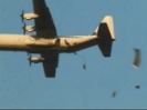
DOE can conduct aerial background radiation surveys to record the location of radiation sources and produce maps showing existing radiation levels within U.S. cities. Background radiation can come from a variety of sources, such as rock quarries; granite found in buildings, statues, or cemeteries; medical isotopes used at hospitals; and areas treated with high amounts of fertilizer, such as golf courses. DOE uses helicopters mounted with external radiation detectors and equipped with a global position system to fly over an area and gather data in a systematic grid pattern.
Figure 1 illustrates a helicopter conducting an aerial survey and collecting information on radiation sources in a city.

Onboard computers record radiation levels and the position of the helicopter. This initial, or baseline, survey allows DOE technicians and scientists to produce maps of a city showing the locations of high radiation concentrations, also known as “hot spots.” DOE uses helicopters rather than airplanes because their lower altitude and lower speed permits a more precise reading. While conducting the baseline survey, DOE ground teams and law enforcement officials can investigate these hot spots to determine whether the source of radiation is used for industrial, medical, or other routine purposes. DOE officials told us that this baseline information would be beneficial for all major cities because law enforcement officials could immediately investigate any potentially dangerous nuclear or radiological source and DOE could later use the data in the event of an emergency to find a device more quickly or assist in cleanup efforts. For example, in 2002, DOE conducted a survey of the National Mall in Washington, D.C., just prior to July Fourth celebrations. Law enforcement officials used the survey to investigate unusual radiation sources and ensure the Mall area was safe for the public. Data from the baseline survey would help DOE and law enforcement detect new radiological threats more quickly. In the event of a dirty-bomb threat, DOE could conduct a new, or follow-up, survey and compare that radiation data to the baseline survey data to identify locations with new sources of radiation. Law enforcement officials looking for a nuclear or radiological device would focus their attention on these new locations and might be able to distinguish between pre-existing sources and potential threats in order to locate a dirty bomb or nuclear device more quickly. Conducting baseline surveys also provides a training opportunity for DOE personnel. DOE officials told us that regular deployments helped to keep job performance standards high for pilots, field detection specialists, and the technicians who analyze the data. DOE can also use a baseline radiation survey to assess changes in radiation levels after a radiological attack to assist with cleanup efforts. A follow-up survey could be taken afterward to compare changes against the baseline radiation levels. This information can be used to determine which areas need to be cleaned and to what levels. In 2004, DOD funded a survey of the area around the Pentagon in Northern Virginia in order to assist with cleanup efforts in case of nuclear or radiological attack. While no study has reliably determined the cleanup costs of a dirty-bomb explosion in an urban area, DOE estimates that cleaning up after the detonation of a small to medium-size radiological device may cost tens or even hundreds of millions of dollars. DOE officials estimated that information from background radiation surveys could save several million dollars in cleanup costs because cleanup efforts could be focused on decontaminating buildings and other areas to pre-existing levels of radiation. Without a baseline radiation survey, cleanup crews would not know the extent to which they would have to decontaminate the area. Efforts to completely clean areas with levels of pre-existing radiation, such as granite buildings or hospitals, would be wasteful and expensive.
DOE officials cautioned that background radiation surveys have limitations and cannot be relied upon to detect all nuclear or radiological devices. Aerial surveys may not be able to detect certain nuclear or well-shielded radiological materials. Weather conditions and the type of building being surveyed may also reduce the effectiveness of detection systems. Furthermore, DOE may have to rely on good intelligence to find a device. Law enforcement officials would need intelligence information to narrow the search to a specific part of a city. Lastly, according to DOE officials, baseline background radiation surveys may need to be conducted on a periodic basis because radiation sources may change over time, especially in urban areas. For example, new construction using granite, the installation of medical equipment, or the heavy use of fertilizer all could change a city’s radiation background. Despite these limitations, without baseline survey information, law enforcement officials may lose valuable time when searching for nuclear or radiological threats by investigating pre-existing sources of radiation that are not harmful. In addition, if there were a nuclear or radiological attack, a lack of baseline radiological data would likely make the cleanup more costly and time consuming.
URL: http://www.gao.gov/assets/120/118643.pdf | http://cryptome.org/gao-06-1015.htm
____________________________________________________________
“Last Secret of the A-Bomb”
In this series of slides, one of the slides says “elevated radiation” was found near Israeli Consulate on Second Avenue.
Below are slides from: “Last Secret of the A-Bomb” by Paul DeRienzo, Executive Producer. Published May 28, 2015
URL: Last Secret of the A Bomb
Slides from “Last Secret of the A Bomb”
Elevated radiation on Second Avenue near Israeli Consulate


URL: http://www.slideshare.net/pderienzo/last-secret-of-the-a-bomb
_____________________________________________________________
The following article is from NTI. Date of report: 22 Sept, 2006
Quote:
U.S. Radiological Response Vulnerable to Attack, GAO Says
WASHINGTON — The U.S. Energy Department’s radiological disaster response teams as well as specialized equipment are concentrated at two under-secured sites, and response capabilities could be devastated by a terrorist attack on either location, the Government Accountability Office warned in a report issued yesterday (see GSN, Sept. 7).
Specialized Energy Department teams trained to locate and deactivate a nuclear or radiological device and assist in the aftermath of a nuclear event are housed at two air force bases. Dubbed the Remote Sensing Laboratories, they are found at the Nellis Air Force Base in Nevada and Andrews Air Force Base just outside Washington, D.C., in Maryland.
In addition to personnel trained to conduct radiological searches and surveys, the facilities house special planes and helicopters outfitted with detection devices. If a nuclear device were to be set off in a U.S. city, response teams could survey the area from the air to measure and map ground radiation levels.
Such detection and response capabilities have taken on a greater significance in the wake of the attacks of Sept. 11, given a heightened concern that terrorists may attempt to employ radioactive materials in a dirty bomb attack or detonate a nuclear device, the GAO report says.
However, the nation’s ability to respond to such a situation would be seriously jeopardized by an attack on either of the two air force sites, the GAO found. Energy Department officials “told us the loss of the capabilities and assets that are unique to the Remote Sensing Laboratories would devastate the department’s ability to respond to a nuclear or radiological attack,” the report says.
The flow of information about the extent and level of contamination to state and local governments would be seriously slowed, the report finds. If either site were attacked, no contingency plan exists to ensure that a radiological response teams can still be fielded.
Since 2001, the Energy Department has expanded its radiological search capability beyond the two labs to eight sites spread across the country as part of a Radiological Assistance Program. Still, the department has failed to designate which of these so-called RAP teams would take the lead if the consequence management squad from Nevada were unable to, the report says.
An April 2006 report by the Energy Department’s oversight branch found that RAP teams, during performance tests, could not quickly provide local governments with advice on what actions to take to reduce the public’s exposure to radiation or whether to evacuate areas. In addition, department officials told the report’s authors that responding to two simultaneous events would strain the department’s capabilities.
Despite being located at military sites, the report warns that the two laboratories are not adequately protected. Anyone possessing a government identity badge can gain access, according to the report, and the sites are required to have only a minimum of physical security measures.
While the facility at Nellis exceeds security requirements with a fence and vehicle barrier at the front entrance, the lab at Andrews Air Force Base does not — something the GAO labeled as a problem.
Located along the route the president and visiting dignitaries travel after landing at Andrews Air Force Base, the building must meet certain aesthetic requirements which prohibit the installation of a fence, the report says.
The report also identifies a level of interagency mission confusion that has prevented nearly all U.S. cities from conducting baseline background radiation surveys that would be useful in the event of a radiological attack. Only New York City has asked the Energy Department to conduct a radiation survey.
Over four weeks in the summer of 2005, a department team spent 100 flight hours over the city mapping radiation levels. The study — which was funded with a portion of a $30 million homeland security grant — identified more than 80 locations with levels of radiation.
While most of them were facilities with medical isotopes, one site was a public park contaminated with radium, a radioactive material associated with bone cancer.
Such surveys would be immensely beneficial if investigators were ordered to find a suspected radiological device, the GAO report says. Existing sites with radiation signatures would already identified and could be eliminated from the search.
However, the Energy Department officials said they are reluctant to conduct more of these aerial surveys due to a limited number of planes and helicopters, the report says. In addition, they said they had insufficient funding for such studies and were concerned about wear and tear on the equipment.
The Energy Department claimed the surveys are within the Homeland Security Department’s realm of antiterrorism responsibility, according to the report. Homeland Security officials said such aerial studies were, in fact, not part of their responsibilities.
A third agency, the Domestic Nuclear Detection Office, which is in charge of detecting nuclear materials at the country’s ports of entry also told the GAO that such surveys are also not their responsibility.
“In the absence of clear mission responsibility, there are no plans to conduct additional surveys, and no other city has requested one, in part because DOE and DHS are not informing cities about the benefits,” the report says.
The Energy Department categorically rejected the GAO contention that the labs at the two military sites are underprotected, and Homeland Security officials accepted the GAO recommendations to improve security and consider grants for more radiological surveys.
http://www.nti.org/gsn/article/us-radiological-response-vulnerable-to-attack-gao-says/

DOE Helicopter Conducting an Aerial Background Radiation Survey gao.gov
The report can be downloaded here GAO Report
__________________________________________________________